|
|
|
|
|
|
|
|
|
Research Notes 2021
| December 2021- Haytor |
| 1)
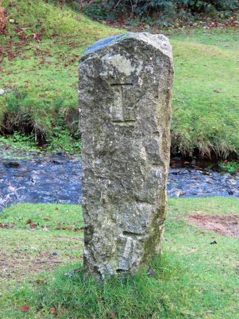
Becka Brook Clapper Bridge (new) - (SX7477/7788)
A write-up of the new Becka Brook clapper was included in the notes for the February 2015 walk. The recent addition of a plaque on the side of the bridge has now been added to the original notes. 2) Boundary Stone near Becka Brook Clapper Bridge (new) - (SX7477/7788)
|
| November 2021- Widecombe |
| 1)
Two Crosses Cross (SX7077/7633)
Information about the Widecombe Two Crosses Cross can be found on our Dartmoor Crosses website. 2) Hutholes Medieval Village (SX702/758)
Some time after the houses were rebuilt, the weather on Dartmoor gradually started to become colder and wetter and the workers gradually started moving off the moor to live in areas at a lower elevation and with a more temperate climate. As each building was abandoned the structure was taken over to be used as a barn for storing and drying crops, a task which became ever more difficult as the years progressed. Eventually, by the middle of the 14th century, the whole site had become abandoned due to the difficulties of growing, ripening and drying crops in worsening climatic conditions. This is contemporaneous with other sites on the moor, including the Hound Tor Village.
3) Drywell's Cross (SX7010/7534) Information about the Drywell's Cross can be found on our Dartmoor Crosses website. 4) Malim Plaques - Rowden Tor (SX6992/7588)
Jeffrey Malim had adopted the name 'Moorover' for his travels on the moor and would set off for his explorations with three comrades, one of whom was known as 'Mooroaman', whose real name was Fredrick Symes. Mooroaman was a notorious local who had moved into the vacant Huntingdon Warren Farmhouse after it had been abandoned and lived there as a recluse. (Source: Legendary Dartmoor Website).
|
| October 2021- Bel Tor Corner |
| 1)
Ouldsbroom Cross (SX6849/7351)
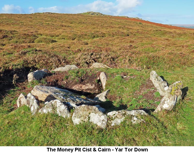
Information about the Ouldsbroom Cross can be found on our Dartmoor Crosses website. 2) Money Pit (Cist/Cairn) - Yar Tor Down (SX6817/7386)
3) Cave-Penney Cross - Corndon Down (SX6832/7389) Information about the Cave-Penney Memorial Cross can be found on our Dartmoor Crosses website. 4) Leusdon Churchyard Cross (SX7093/7319) Information about the Leusdon Churchyard Cross can be found on our Dartmoor Crosses website. 5) Dr Blackall's Drive (SX694/731 to 707/716) The original notes written up for Dr Blackall's Drive, in December 2015, have now been updated.
|
| September 2021 - Belstone |
| 1)
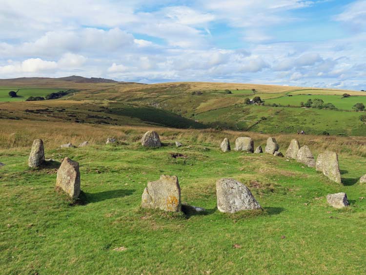
Nine Maidens Stone Circle - (SX6123/9284)
The Nine Maidens Stone Circle is the remains of a Bronze Age burial site. The circle of stones surround a depression in the centre of the circle, which is all that now remains of what was once a burial cist. The stone circle also goes by the name of the Seventeen Brothers, based on the number of stones in the circle, although no-one is quite sure whether there are sixteen or seventeen of the original stones remaining.
The locals are very apprehensive about undertaking any restoration work or other interference with the site, believing that anyone tampering with the stones will immediately attract a curse. As an example, an episode in 1985 is quoted where a film crew was due to shoot a scene for a film at this spot. Prior to filming, the company added a further stone to the circle to fill in one of the gaps. On completion, the only copy of the film, 'The Circle of Doom', was put in the post and has, due to the curse, never been seen again. Another fact about the stone circle is that it has St Michael's ley-line running right through the centre of the circle. This is one of the major ley-lines, which runs for 350 miles from Lands End to Hopton-on-Sea, in Norfolk, passing through Glastonbury Tor on its way. The ley-line also lines up with the sunrise each 8th May, which is the date on which the Catholic Church celebrated the apparition of St Michael. (Source: Eric Hemery - 'High Dartmoor', pages 856-7, Wikipedia & Legendary Dartmoor websites).
|
| August 2021 - Cadover Bridge |
| 1)
Cadover Bridge to Shaugh Bridge Clay Pipeline - (SX555/645 to SX533/635)
Back in the second half of the 19th Century, clay was being extracted from the Shaugh Lake China Clay Works - what is now a vast area to the south-east of Cadover Bridge. After extraction, the clay was suspended in water and piped for around two miles alongside, but above, the River Plym to Shaugh Bridge. The dual pipeline was, in the main, itself made of clay with some stretches, mainly the steeper gradient sections, made from iron. Along the way several inspection pits were built into the pipeline which could be used to help pinpoint and clear any blockages in the pipes. At the rear of the Shaugh Bridge car park are the remains of the clay settling pits. Here, the water would be gradually drained off and the clay would get thicker and thicker as it flowed down from pit to pit. The final act was to spread the clay on the floor above the furnaces, where the heat would dry it out completely and it would then be cut into blocks for onward transmission. The blocks of clay would be loaded onto a horse-drawn cart for transportation to a nearby railway station, which tended to be at either Shaugh or Bickleigh, for transport to its final destination. The clay works were run by the Watts, Blake and Bearne Company and there is a stone somewhere among the settling pits, inscribed 'WBBC 1895'. Watts, Blake and Bearne are still involved in clay mining in the area although, in more recent years, they have been absorbed into the Sibelco company, a Belgian conglomerate. Their activity is currently centred on the Shaugh Moor, Wotter and Lee Moor pits. (Source: Various websites). 2) Shaugh Prior (modern) Cross - (SX5412/6314) At the side of the road in Shaugh Prior stands a fairly recently sited cross which, at first glance looks really authentic, but further investigation reveals it to be a modern imposter. It is, in actual fact, made of a synthetic material, probably fibreglass, and has been rendered on the outside. A light tap on the cross with your knuckles shows the cross to be hollow in the centre. The cross has the words 'SHAUGH PRIOR' written in large letters across its head. Further details of this cross can be found on the Dartmoor Crosses website. 3) Shaugh Prior Churchyard Crosses - (SX542/630) The Shaugh Prior Churchyard contains parts of three separate crosses. Above the churchyard road wall stands the village War Memorial Cross, with a further cross base laying flat amongst the gravestones nearer the actual church and the shaft of a third cross forms a coping stone to the wall running alongside the steps up to the eastern Churchyard Gate. Details of the cross base and shaft can be found on the Dartmoor Crosses website. The War Memorial Cross has not yet been posted up to the website, but this will happen in due course. 4) Shaugh Prior Village Cross - (SX5443/6308) The Shaugh Prior Village Cross juts out from a garden wall, just up from the road junction in Brag Lane. More information on this cross can be found on the Dartmoor Crosses website. 5) Beatland Corner - (SX548/624)
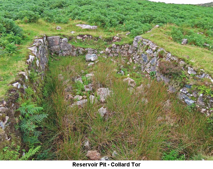
6) Shaugh Moor Radar Station - (SX5502/6228) About 250 yards to the south east of Beatland Corner are the remains of a World War II Radar Station, named RAF Hawks Tor. The station was established by 18th April 1941 as one of a chain and numbered 'CH15M'. The main purpose of this site, similar to all the others in the chain, was to detect approaching enemy aircraft. The site was fairly extensive and included Mast Bases, Transmitter & Receiver Blocks, a Generator Base, Gun Emplacement, Air Raid Shelters, Guard Rooms and Administrative Buildings etc. The whole site has now been demolished, but there is still plenty of rubble to be seen on the ground where the various buildings and blocks were previously sited. More detailed information on RAF Hawks Tor can be found on the Dartmoor Explorations website. 7) Collard Tor Reservoir Pit - (SX5574/6213)
8) Hawks Tor Shelter - (SX5539/6250)
9) Hawks Tor Boundary Stone - (SX5537/6247)
|
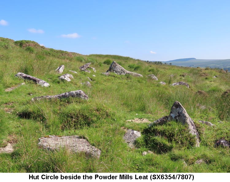
| July 2021 - Postbridge |
| 1)
Powder Mills Leat - (SX634/794 & SX628/794 to SX629/775)
|
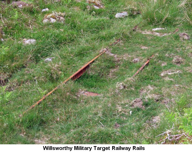
| June 2021 - Willsworthy |
| 1)
Lord Mayor's Castle - (SX5615/8361)
2) Willsworthy Military Target Railway - (SX5377/8321)
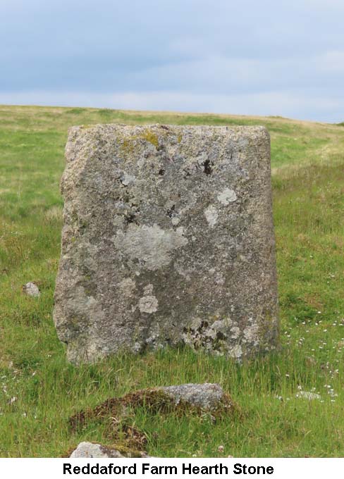
3) Reddaford Farm - (SX5372/8335)
Purchased
from the Calmady-Hamlyn estate by the War Office in 1905 to create a
live firing rifle range at Willsworthy the farm was abandoned in 1907/8
after a family called Palmer were the last to occupy it, having been
domiciled there since at least 1861. Family descendants still live in
West Devon. Within twelve years of being deserted the farm was a
roofless shell, remaining so until the outbreak of WW2 and by the end of
or shortly afterwards it had been completely razed. It is thought
Howitzers were used to shell and more or less reduced it to its current
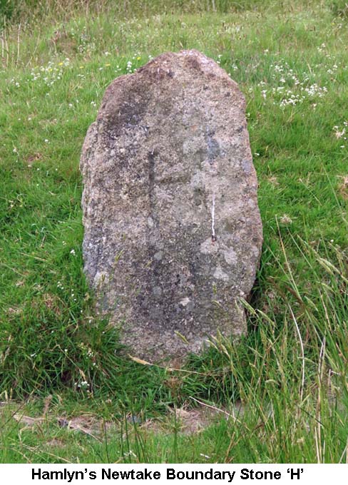
condition, with much stone subsequently removed from the site. There was mention of a dwelling here in 1334 and earlier documentation from 1242 uses the place name of Reddaford (Redeforde). Over the years the farm had been the abode of many families. Numerous spellings for it have been used, e.g. Redeford (1342), Redever (Revd Sabine Baring-Gould - 1896), Ruddyford (Eden Phillpotts - 1907) and Redford/Ruddiver (Crossing - 1909). It is thought the name translates to “reedy ford”. (Source: Greeves, Hemery & Crossing). 4) Hamlyn's Newtake Boundary Stones - (SX5393/8297 & SX5226/8327)
By 1915, during the First World War, it was estimated that Devon's farms had lost in excess of 15% of their male workforce. Although she met a great deal of opposition from the male population, who argued that women were not strong enough and 'not up to the job', Sylvia became very successful in recruiting women to fill many of the job vacancies. In this, she worked with the Women's Land Army and also sat on the Women's War Agriculture Committee. In 1917, she established the first farm to be run and staffed purely by women, at Great Bidlake, Bridestowe. When the war had ended and her Board of Agriculture work done, Sylvia returned to her beloved Dartmoor where she resumed her love of breeding Dartmoor Ponies. She later became one of the first female magistrates and was awarded an MBE for her service to agriculture during the war. (Source: Exeter RAMM website).
|
| May 2021 - Little Staple Tor |
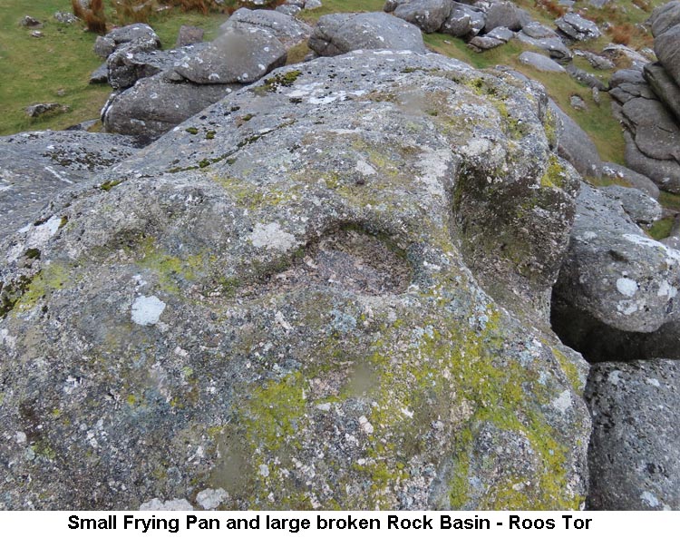
| 1)
Rock Basins - Little Staple Tor (SX5387/7538) & Roos Tor
(SX5433/7660)
2) Roos Tor Boundary Stones - (SX5444/7670, SX5438/7673, SX5433/7675 & SX5429/7676) The history of the Boundary Stones, inscribed with 'B', and the Stonemason's Markers around Roos Tor was covered in our Research Notes of August 2014. 3) Stephen's Grave - (SX5359/7813) Notes on the story behind Stephen's Grave can be found in our Research Notes of October 2019.
|
| April 2021 - Moretonhampstead |
| 1)
Wray Valley Trail - (SX7529/8556 to SX8139/7824)
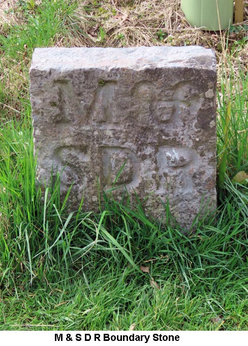
The trail continues in a southerly direction until it reaches the road at Lustleigh, just down the hill from the old Railway Station, to the north of the village. At the side of the path, just before reaching the road, is one of the old boundary stones relating to the railway. The stone is engraved with 'M & S D R' (Moretonhampstead & South Devon Railway). As an aside, there are two further 'S D R' boundary stones placed each side of the main entrance door to the DNP Authority's headquarters at Parke, Bovey Tracey. On reaching the road, the official route of the trail advises turning left (south-east), taking a right at the next road junction and then going south along a quiet road and rejoining the trail just to the south of Drakeford Bridge. However, personally I prefer to turn right (north-west) at the road and visit the village centre.
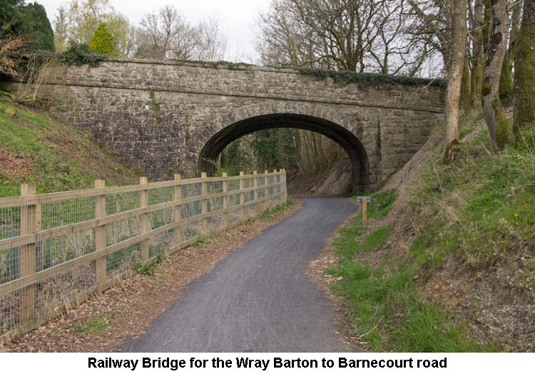
To get back on the trail from the village centre, go south from the church and turn left just after crossing over the stream. Carry on along this road until you reach a T junction, with a red-roofed house in front of you. Turn left, cross over the stream, carry on up the hill, under the old railway bridge, turn right at the next T junction and the trail will be signposted on your right a little way along this road. Alternatively, take the footpath from the village green, pass through Wreyland and turn right onto the road of the official route shortly after. On rejoining the trail, it continues off-road all the way to the outskirts of Bovey Tracey, where it passes, very close to the River Bovey, under a bridge for the A382 and into Mill Marsh Park. The trail ends at the far end of the park which is right in the centre of Bovey Tracey. (Source: Maurice).
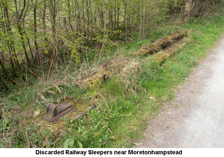
2) Moretonhampstead & South Devon Railway - (SX868/715 to SX756/856)
As the route of the railway passes through Sanduck Wood (SX772/837) there are signs of a siding being present, for which the reason is not immediately obvious. It would seem that in the 1870s the Earl of Devon had persuaded the railway company to install a 120 foot long siding for transporting cut timber away from his woodland for commercial gain; this is obviously now long gone! A bit further north, towards Moretonhampstead, from this former siding the railway follows the original course of the Wray Brook for the next quarter of a mile or so. This was done to prevent flooding during winter months with a deeper artificial channel being cut to divert the brook.
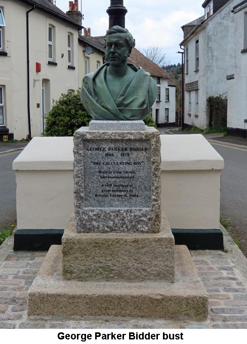
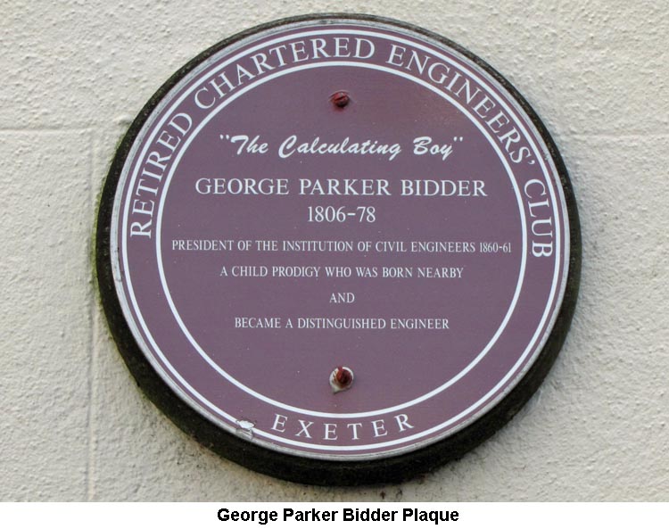
The rest of the line, between Newton Abbot and Heathfield, continued for the occasional transport of oil and china clay for several years, but this ceased in 2009. Just two years later, in 2011, it was announced that the line would be re-opened as far as Teigngrace for the transport of timber. A new siding was opened at Teigngrace, just before the level crossing, so that the timber could be loaded onto the train for transport, via Newton Abbot, to its destination in North Wales. The original course of the line between Bovey Tracey and Moretonhampstead now forms the basis for the route of the Wray Valley Trail. (Source: various internet sites). 3) The Bishop's Stone - (SX7860/8153) Information about the The Bishop's Stone can be found on our Dartmoor Crosses website. 4) Lustleigh War Memorial Cross - (SX7852/8136) Information about the Lustleigh War Memorial Cross can be found on our Dartmoor Crosses website. 5) Lustleigh Village Cross - (SX7851/8125) Information about the Lustleigh Village Cross can be found on our Dartmoor Crosses website. 6) George Parker Bidder bust - (SX7537/8609)
George was born on 13th June 1806, the third of three sons, to William Bidder, who was a local stonemason, and Elizabeth Parker. Of his two brothers, William became a nonconformist minister and John followed in his father's footsteps as a stonemason. George was never a very bright boy in general terms, but he had an amazing ability to perform very complex mathematic calculations in his head. He would be able retain a series of large numbers in his head and work his calculations with them, just as though they were written down on a piece of paper in front of him. This ability first came to light when he was laying in bed and heard other members of his family struggling to calculate the price they would get for a pig that was about to be sold. While the family were arguing over the calculation, George, having overheard the argument, had quickly worked out the right answer and shouted it down the stairs in frustration. His father was quite quick in cashing in on his son's extraordinary ability and took him around all the local shows and fairs to demonstrate his talent. Later, they started to go further afield and visited such places as London, Oxford, Cambridge, Norwich and Birmingham. To show just amazing his talent was, I show below a few of the questions that George had been asked, together with his answers which had all been worked out in his head: a) If a coach-wheel is 5 feet 10 inches in circumference; how many times would it revolve in running eight hundred million miles? George was able to give the answer in only 50 seconds - 724,114,285,704 times and 20 inches remaining. b) What is the interest of £4,444 for 4,444 days, at 4½ per cent. per annum? The answer George gave was £2,434 16s. 5¼d, in only 2 minutes. c) Multiply 72,468 by 87,468? - Answer, 6,338,631,024 in 90 seconds. d) What is the square root of 119,550,669,121? George replied 345,761 in just 30 seconds. At the age of 10, he was invited by Queen Charlotte, the wife of King George III, to visit her in order that she could put some mathematical problems to him so that she could see his special ability for herself. Whilst on a visit to Edinburgh, in 1819, he came to the attention of a group of scholars, led by Sir Henry Jardine who offered to sponsor his education. After spending a year with a private tutor, George studied mathematics and Natural Philosophy at Edinburgh University, graduating in 1823. George later repaid Jardine and his group for their generosity, by establishing the Jardine Bursary at the university for students of limited means. Whilst at Edinburgh University, he met and struck up a life-long friendship with fellow student, Robert Stephenson. After his graduation, George moved to London where he worked as a surveyor for the Ordnance Survey, before taking on various engineering projects, such as building new docks, railways and canals. In 1834, he joined his friend Robert Stephenson to work on the new London & Birmingham Railway. This partnership worked very well and George was renowned for being able to accurately estimate the cost and time it would take to deliver a project. George could also foresee that the new Electric Telegraph was going to be a very important feature for the railways in the future and he persuaded the London & Blackwall Railway to install the system to optimise their operation. This was so successful that other railways soon followed suit.
In 1835, George married Georgina Harbey and, despite the fact that George was working away from home for long periods, they had 8 children and 28 grandchildren. Eventually, in 1860, George bought a house with some land at Paradise Point in Dartmouth in advance of his retirement. As he spent more time in Dartmouth and taking an interest in local affairs, he decided to run for a place on the local Council and, topping the poll, he served as a councillor for three years from 1868. He also took up sailing buying his own impressive yacht, The Mayfly, and became a founder member of the Dart Yacht Club. He was also instrumental in the club gaining a Royal Warrant. In 1877 he bought Stoke House in Stoke Fleming which he planned to enlarge and update. Unfortunately, he died on 20th September 1878, and was buried in the local churchyard, before the work on the house could be completed. (Source: George Bidder Information Board & Internet).
|
.jpg)
.jpg)