|
|
|
|
|
|
|
|
|
Research Notes 2017
| December 2017 - Trenchford Reservoir |
|
1) Great Rock Mine - (SX825/815) Great Rock Mine and Milling Plant is situated about half a mile to the north west of Hennock Village. The mine, which dates from 1822, was initially known as Hennock Iron and Tin Mine. The mine worked five iron lodes, which were the Main South Lode, Middle Lode, Beadon Lode and two smaller North Lodes. In 1849, Hennock Mine produced 1,600 tons of iron ore and production continued until 1889. In 1902, the Ferrubron Manufacturing Company took over a lot of the local iron ore mines, renaming the Hennock Mine as 'Great Rock', and only keeping this and the Kelly mines open. Great Rock, being in the granite belt, was known for its micaceous haematite, a shiny almost powdery substance obtained from iron ore, which was used in the manufacture of rust-resisting paint. On reopening, peak production of about 2,500 tons per year was achieved in the 1940's, with the Royal Navy one of its biggest customers. The mine, which was the last working mine on Dartmoor, was finally closed down in 1969. In the late 1970's and early 1980's parts of the mine were used for student training by the geology department of Leicester University. Great Rock supplied the powdery ore which was used in the painting of Plymouth's Royal Albert Bridge, the Sydney Harbour Bridge and the painting of battleships, tanks and railway bridges, etc. It has also been used in the past as a powder sprinkled onto wet ink, before the advent of blotting paper and was known then as 'Pounce' and also as 'Devonshire Sand'. Jim Hine, who lived at Great Rock, left school in 1948 and went to work for the paint company in London - Griffiths Bros of Bermondsey. At church on a Sunday, you could always tell who worked at the iron ore mines. No matter how smartly they dressed up, the men would always have a revealing sheen on their faces or clothes from the shiny ore, micaceous haematite. Because of labour shortages during World War II, women went to work in the mine at Great Rock. Nesta Burton from Hennock was the first woman to be employed there by Ferrubron. Up until the 1920's waterwheels provided the power for the mines. Electricity was first used as late as 1950. Ron Tucker remembers buying some old fairground machinery before electric power had reached the mine and hooking it up to the waterwheels at Great Rock, which then provided enough power to run a few light bulbs in the premises down at the mine. The ore extracted from the mine occurs in shiny platelets and is known locally as 'Shiny Ore'. The mines were also often referred to as 'Treacle Mines', as the glistening black residue, being soft, would flow and look like treacle. This might well be connected to the origin of the Dunchideock Treacle Mines, which is a joke that has been around since at least the middle of the 19th Century. (Source: Hennock Village Signboard & Internet Searches).
This gravestone is set into the ground immediately inside the lych gate of the Hennock Churchyard. The engraving on the stone is not easily read, but is something like: "1603 / Here Lieth / Richarde / Washer He / Died 1st of March". The year of 1603 is not clear as it looks more like 1003 on the stone. The stone commemorates the Reverend Richard Washer, vicar of Hennock from 1575 to 1603 and who was buried on 20th March 1603. The inscription in the bottom left hand corner of the stone has now become very worn and difficult to read. (Source: George Thurlow's 'Dartmoor Companion', page 353 & Internet Search).
|
| November 2017 - Tolchmoor Gate |
|
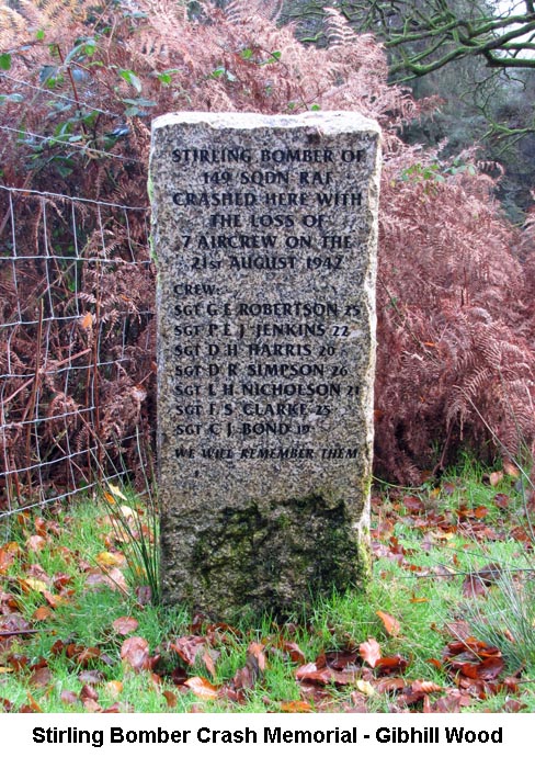
1) Tolchmoor Gate Holed Stone - (SX5806/6164) The large stone, with a square hole running through it, in the lay-by at Tolchmoor Gate was once one of a pair of gate posts that was used in this spot on the road. When in use it was sited on the edge of the road and, in order to close the road, a large, heavy bar was slid through the holes of both stones to form a barrier. The road was widened in the mid 1930's and, as there was no longer a need to close the road at that time, the redundant stone was moved further back into the lay-by. (Source: Eric Hemery's 'High Dartmoor', page 210). 2) Cholwichtown Farm Cross - (SX5862/6119) The details of the Cholwichtown Farm Cross can be found on our Dartmoor Crosses website. 3) Stirling Bomber Memorial - (SX5943/5987)
The
Stirling had taken off the previous evening at 20:45 from 149 Squadron’s
base at Lakenheath in Suffolk for a mine laying operation off the French
coast near Bordeaux and the Gironde Estuary. Encountering heavy
anti-aircraft fire in the target area, and presumably sustaining damage,
the pilot managed to bring the aircraft back to England flying at low
level. It would have been on a homing for Exeter, which was predetermined
for damaged bombers returning from the west coast of France. Not
knowing how serious the situation and conditions were for the air crew it
is considered they mistook the Lizard lighthouse for the one at Land’s
End. By flying to the right of the Lizard they would have flown directly
over Plymouth. If unable to give the recognition signal for a friendly
aircraft the anti-aircraft defences there would probably have opened fire,
dealing the aircraft a fatal blow. The Stirling, built by Short
Bothers and Harland & Wolff, had only flown 153¾ mission hours and
upon recovery its engines were reused. In 2009 two villagers from Lutton were walking in Gibhill Wood when one of them happened to notice a cross carved on one of the trees. It was learned that it had been done in 1942 by RAF recovery personnel to mark the spot where a Stirling bomber had crashed. Following investigations the two decided there should be a more permanent memorial to the crew. In doing further research they also discovered that two other villagers were pursuing a similar plan. The four joined forces and engaged the community behind the project. Delamore Estate, the owners of the land where the aircraft came down, gave permission for the memorial to be erected and provided the granite block used. South Hams Council enabled funds for the wording and names of the crew members to be engraved of the face of the memorial. On April 11th 2011 the stone was unveiled and a service of dedication held. (Source: ‘A Book of Remembrance for the Crew of Stirling Bomber R9329 of 149 Squadron’ (Internet source) and ‘Wings Over Dartmoor’ by Graham Lewis). 4) H.H.T Stone - (SX5697/5818)
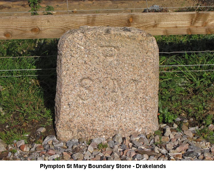
The 'H.H.T. refers to Henry Hele Treby, who was from a notable Plympton St Mary family. He was born on 28th May 1800, at Plympton House in Plympton St Mary, to father Paul Treby Treby and mother Letitia Ann Trelawny. By the time of his father's death, in 1832, the family had moved to Goodamoor House, with their previous residence being let out to a succession of tenants. Goodamoor House is now the home of Ben Mee, proprietor of the Dartmoor Wildlife Park and is situated at the heart of the zoo. This is only a short distance from the original site of the stone, which would have been at the edge of the Goodamoor Estate. Henry Hele Treby died at the age of 66 on 3rd April 1867, at Goodamoor House. A couple of interesting points about Henry Hele's father, Paul Treby Treby, are that he was born Paul Treby Ourry, whose grandfather was Louis Ourry, a Huguenot refuge from Blois, in France and changed his name to Paul Treby Treby by Royal Licence in 1785. Paul Treby Treby must also have been the master of the local hunt as his name appears prominently on the Hunter's Stone, a short distance up the track from Shipley Bridge. (Source: Bob W's Internet Search & Dave Brewer's 'A Field Guide to the Boundary Markers on and around Dartmoor', pages 80/81). 5) Plympton St Mary Boundary Stone - (SX 5625/5923)
|
| October 2017 - Postbridge |
|
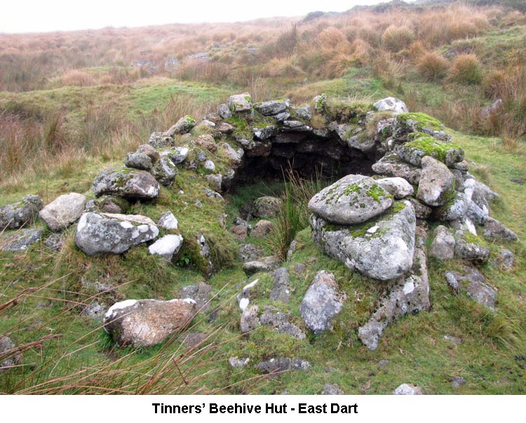
1) Muck's Hole Bridge - (SX6487/7946) Muck's Hole Bridge spans the Stannon Brook on the lane between Ringhill and Higher Merripit Farm. The surface of the bridge is just normal road tarmac, but underneath it is supported, in the traditional Dartmoor manner, with granite boulders. It is different from many road bridges in that two large granite boulders have been laid across the bridge on the road verges, presumably to prevent vehicles from running off the road and into the brook. The two stones seem to have been laid just above road level to allow any surface water to drain away beneath them and into the brook. I've not been able to find the reason why the bridge has been so named, but the nearby gate across the road has been similarly named as Muck's Hole Gate. (Source: Eric Hemery's 'High Dartmoor', page 503). 2) Grey Wethers Stone Circles - (SX638/831) The two stone circles at Grey Wethers lie between the North and South Teign Rivers and the Lade Hill Brook. Prior to 1909 only sixteen of the stones were standing, but Robert Burnard came along and restored all the fallen and buried stones to their original position, as accurately as he was able. Each of the circles had thirty stones, which was one more than the similar circle at Fernworthy and the diameter of the circles differ by only 0.7 of a metre. Shallow pits within the circles were made by trial excavations by the Dartmoor Exploration Committee in 1898 where they found, similar to the Fernworthy Circle, a layer of charcoal covering what would have been the original ground surface. As with many famous Dartmoor landmarks, there are a couple of legends attached to these circles. The first concerns a farmer who, whilst imbibing a pint or two at the Warren House Inn, was persuaded to buy a flock of Grey Wethers (Sheep) 'out to Siddaford'. It was only later, when he rode out to view his purchase that he realised that he had been 'fleeced', rather than having bought a flock of fleeced animals. The second is that a wife, in order to expiate her sins, would have to perform a number of rituals at sites across the moor. The last of which was to kneel before one of the stones in the circles and pray for forgiveness. If nothing happened, she was forgiven and she could rise up and walk away. However, if the Lord of the Rings deemed her transgressions as unforgivable, the stone would fall down upon the unfortunate woman. This is believed to account for all the fallen stones over the years prior to its restoration. (Source: Jeremy Butler's 'Dartmoor Atlas of Antiquities', page 165, Eric Hemery's 'High Dartmoor', page 767 & John Hayward's 'Dartmoor 365', page 126). 3) Beehive Hut - East Dart (SX6393/8145)
|
| September 2017 - Roborough Rock |
|
1) RAF Harrowbeer - Roborough Down (SX515/677) In the 1930's, the Plymouth City Council began a search for a new airfield and Harrowbeer was the chosen site from a short-list of three, the others being Chelston Meadow and Roborough. The only drawback was the possibility of the site becoming fog bound in certain weather conditions. The airfield was constructed during the second World War and vast quantities of rubble cleared from the blitz of Plymouth was transported to Yelverton for use as hardcore for the runways. The surface was coated with tarmac to provide for a smooth take-off and landing. All the shops in the centre of Yelverton were reduced to a single storey to reduce the possibility of airplanes crashing into them on take-off and landing. A number of other properties were completely demolished at the site of where the roundabout now stands. There was a rumour the top of Roborough Rock had been removed to make it easier for the airplanes to manoeuvre, but has since been proved to be false. The base became operational in 1941 and was at first occupied by 500 squadron, flying Bristol Blenheims. Later that year a number of Hurricanes landed at the airfield. The base continued to expand and develop and, in 1944, Harrowbeer along with many other RAF Stations became involved in Operation Overlord, the D-Day Invasions. During the invasion, Spitfires took off from Harrowbeer to defend against the expected enemy attacks. The end of the invasion was the start of the demise of RAF Harrowbeer and by August 1944, it had ceased to exist as a base in it's own right and became a satellite of RAF Exeter. The Air Ministry took the decision, in 1950, that it no longer required a base at Harrowbeer and the process of its de-requisitioning began. Initially only the hangars, huts and fences were removed and the runways were left intact. After the war, the aircrew's billets were used as temporary accommodation for local families and some of these were still in use until the 1970's. At one point the Plymouth Corporation attempted to acquire the site for their own civil airport, but this was rejected by a House of Lords Select Committee.
2) The Dewerstone - (SX5378/6389) The summit of the Dewerstone appears as an innocuous pile of rocks on the south western edge of Wigford Down and overlooking the wooded valley of the River Plym. However, when viewed from across from the other side of the Plym valley the full size of the jagged rock forms an impressive sight jutting out through the trees right down the hillside. In fact, the summit of the Dewerstone sits within the site of an Iron Age hill fort, which would have had good natural defences from the two steep-sided valleys down to the Rivers Plym and Meavy. The word 'Dewer' is an ancient Celtic word for the Devil, and Dartmoor tradition has it that the Devil, riding a gigantic black horse, gallops across the Moor each night and leads a phantom pack of black hounds to chase weary or foolish humans over the Dewerstone to their deaths. Another legend has it that a shepherd actually saw the black hounds devouring an unfortunate man on his way home from the fields one night. The rocks we saw are just the 'tip of the iceberg'. The summit rock has been engraved with a number of names, the most prominent of which is: 'CARRINGTON / OBIT / II SEPTEMBRIS / MDCCCXXX'. This refers to Noel Carrington, Romantic Dartmoor Poet, who was born in Plymouth in 1777 and died at Bath in 1830. He is buried at Combe Hay, a small village about 5 miles to the south of Bath. Other inscriptions include: F. WIDGER, F. DODDRIDGE and W. FORD. There doesn't appear to be any records to show who these people might have been but, of course, they could merely be the names of ordinary people that have been added to the rock. I did wonder whether 'F. WIDGER' could have been the Dartmoor Painter 'F. J. WIDGERY', but there is no sign of the letter 'Y' at the end of his surname. (Source: Eric Hemery's 'High Dartmoor', page 184 & Wikipedia). 3)
Wheal Lopes Leat (SX52/65 – SX51/63) Encountering this
leat during the first part of the walk came as a surprise. Subsequent
searches regarding its existence have yielded little factual information,
but it appears to have supplied water to a mine located in an area
referred to as Vicarage Wood and Hole Bottom, which is north-west of
Bickleigh Church. Apparently the mine
was initially leased in 1760, but little was known of its workings until
the 1840’s when the Plymouth & Dartmoor Mining Co. acquired the sett.
Although ore was raised the proceeds did not cover costs and serious
financial difficulties occurred due partly to mismanagement. With the plant still
in situ a new group of adventurers decided to form the Wheal Lopes Copper,
Tin & Zinc Mining Co Ltd on 31st December 1859 under a twenty-one year
lease from Sir Massey Lopes of Maristow House. Reliable information
suggested the existence of substantial copper ore with two shafts driven
to depths of 81 and 62 fathoms. It was said that abundant water was
available from the River Plym at a small rent but the Meavy was the source
with a take-off above Hoo Meavy Weir. In view of the dates
involved nothing has emerged concerning whether the aqueduct immediately
south of Shaugh Tunnel existed prior to the railway or not and who was
involved in its construction. Despite marvellous prospects there were insufficient funds to work the mine properly and when some unscrupulous directors misappropriated urgently needed capital the unhappy shareholders cut short their misery by winding the Company up in 1868; it was finally struck from the register in 1882. (Sources: The Northern Mine Research Society (1993) and ‘Walking the Dartmoor Railroads’ by E Hemery). 4)
South Devon & Tavistock Railway (SX519/565 – SX480/739) During the 1830’s
interest was aroused in the railway coming to the area south and west of
Dartmoor and the people of Tavistock desired to embrace this development.
With Brunel having surveyed a route between Plymouth and Exeter in 1836 it
would be twenty-three more years before their dream became reality. When Brunel planned
his route a proposal for an Exeter to Plymouth link via Crediton,
Okehampton and Tavistock was put forward by F Giles (engineer of the
London & Southampton Railway) and in 1840 plans were deposited from a
survey directed by J M Rendel (son of a small farmer and a road surveyor
near Okehampton) for a route, with additional proposals, between Plymouth
and Exeter that traversed the Forest of Dartmoor (via Nun’s Cross) and
included a branch to Tavistock. The success of each
scheme depended on its merits and who in turn supported or opposed it. In
the end the South Devon Railway Co’s extension of the Bristol &
Exeter Railway won through. With work commencing after a Bill of 1844 the
expanding network connected to Plymouth via Newton Abbot and Totnes in
April 1849. For the people of
Tavistock continuing drive, competition and wrangling amongst promoters
and objectors eventually culminated in a branch-line being adopted over a
route surveyed by Brunel that connected with the South Devon Railway near
Marsh Mills. Built to the broad gauge actual construction began in
September 1856 and the line opened officially in June 1859. Our walk picked up
the dismantled track-bed at Shaugh Bridge Platform which had opened in
1907 after many years of representation, and by which time Brunel’s 7
foot gauge had been swept away by the 4 feet 8½ inch standard. The
platform’s site had previously been a siding for the loading of
low-grade ore from Shaugh Bridge Iron Mine which was shipped to South
Wales for smelting. The platform, so busy before the motoring era, closed
to traffic on 21 December 1962. Passing on beneath
the dry and rusting Wheal Lopes Aqueduct and through Shaugh Tunnel a point
is reached near Goodameavy where a siding from Dewerstone Hill Quarry was
to have connected with the railway. Although an embankment and bridge
abutment were constructed on the quarry side to enable the line to
traverse the River Meavy, Sir Massey Lopes (land owner) withheld
permission for this essential undertaking to be completed. We left the
railway not long after at an over-bridge on the Goodameavy Road and headed
for the open moor. The line eventually extended to Launceston, opening to traffic in July 1856. The through route from Tavistock Junction to Launceston closed on 31st December 1962. At Yelverton the branch to Princetown would have connected, being opened in August 1883 and closing to traffic on Saturday 3rd March 1956. (Sources: The Tavistock Launceston and Princetown Railways by G H Anthony and ‘Walking the Dartmoor Railroads’ by E Hemery). Due to growing
mercantile importance in the late 16th century demands for reliable fresh
water supplies made existing sources inadequate for Plymouth’s citizens.
An Act of Parliament was passed in 1585 authorising the City Corporation
to ‘digge a Trenche through and over all the landes and groundes lying
between Plymouth and anye parts of the said river of Mew’. Sir Francis
Drake was appointed the task for a fee of £300 - a sum that had to
finance the work and compensate affected landowners. Local tinners were
employed to cut the entire channel with Drake digging the first sod in
December 1590. It was 18½ miles in length, between 6 and 7 feet wide and
completed on 23rd April 1591. The leat commenced
from a point on the Mew (Meavy) just below Lower Lowery where a wide head
weir and sluice were constructed (SX5580/6885). Its channel followed the
right bank of the river eventually taking a north-westerly direction
around the slopes of Yennadon Down from where it swung south-westerly.
Passing between what is now Dousland and Lake, it would later be conveyed
by aqueduct over the Princetown Railway, went under the Meavy road
skirting around the northerly coombes of the River Meavy to reach
Roborough Down. Today, as it crosses the Down and Yelverton Golf Course it gives the impression, although no longer flowing because Burrator Reservoir has superseded its role, of a well maintained channel. The leat was lined with granite slabs in 1871 and Hemery calculated that some 113,950 of them would have been cut and dressed for this undertaking. As Tyrwhitt's tram-road had fallen into disuse at this time and the GWR branch to Princetown was 12 years in the future it is possible the old tram-road was put back into sufficient working order to transport the stones from the Walkham quarries. The condition of the bed of the leat is due to works undertaken by Plymouth Corporation at the beginning of WWII to ensure an emergency watercourse to the city in the event of the main Burrator supply suffering bomb damage. Numerous clapper bridges will be observed spanning its route over Roborough Down. (Source: ‘Walking the Dartmoor Waterways’ by E Hemery). 6) Plymouth &
Dartmoor Railway – Roborough Down Section (SX517/674 – SX510/636) (See
also Research Notes for August 2015 [1] Thomas Tyrwhitt and the Princetown
Railway) We only followed the
top half of this section from the Clearbrook Road. When Tyrwhitt’s
tram-road was constructed Yelverton did not exist, only the small hamlet
called Elfordtown the name becoming corrupted and applied to the place we
now know; its growth a result of the expanding railway system.
Traversing the Down
the route is traced by the extensive remains of granite setts which
fastened the iron rails at a gauge of 4 feet 6 inches (a section of rail
is in situ at SX5177/6718). Three cylindrical stones (representing
distances of 11, 12 and 13 miles from Plymouth’s Sutton Harbour) are
also to be found, whilst at SX5172/6511 a building known as North (or
Tyrwhitt’s) Wharf still stands where horses were changed, fed and
stabled. The
tram-road can be followed across the Down as far as a point near Roborough
Reservoir where it enters areas of private land. Although the abandoned track bed of the GWR Princetown and Yelverton branch is clearly traceable on the higher moor some parts of Tyrwhitt’s tram-road are not. As far down as Horseyeatt they both shared, with minor deviations, the same route. Afterwards and whereas the GWR branch went to the east of Yennadon Down (Burrator Halt), Tyrwhitt’s line turned south-westerly through the fields of what is now Peekhill Farm crossing the Princetown Road at SX5450/6944. It continued along the west and south-west side of Yennadon Down passing the sites of a disused chalk quarry and iron mine then turning sharply at SX5437/6786. (Source: ‘Walking the Dartmoor Railroads’ by E Hemery). 7) Devonport (or
Dock) Leat - Roborough Down (SX517/674 – SX504/644) (See
also Research Notes for March 2015 Devonport Leat and April 2016
Devonport
Leat - Southern End) At Yelverton the
in-filled leat lies below the road that fronts the shops but its route
continued beneath the A386 where it ran through the corner of Harrowbear
airfield, its channel being used to drain away surface rain water during
WWII. Tracking back under the A386 the alignment of Tyrwhitt’s tram-road
then bisects it to place the leat west of the tram-road as it traverses
Roborough Down. Although it was
constructed some 200 years after Drake’s leat its condition is less well
attended to and its course not so well defined over the down. A bridge at
SX5193/6620 spans its channel providing an opportunity to observe its
southerly direction more so than that to the north. A tunnel 215 yards
long was dug near the Chubb Tor enclosures where the leat was taken under
a small ridge to avoid an inconvenient proximity with Drake’s which an
act of 1793 ruled should not be affected. Like Drake’s it has
clapper bridges that carry old tracks and wood ones for the aid golf
course users. From the point of abandonment above Burrator Lodge, where its current water supply is transferred by pipe to the Dousland Water Treatment Works with any surplus running off into Burrator Reservoir, the dry leat continues around Yennadon Down and enters private land at SX542/682. Passing through fields where it would have crossed Tyrwhitt’s tram-road it reaches the Dousland Water Treatment Works and negotiates a sharp turn to follow the northern side of the Princetown Road through private land and, like Drake’s where it becomes its companion near Woodman’s Corner, was taken by aqueduct over the GWR Princetown branch on its approach to Yelverton. (Source: ‘Walking the Dartmoor Waterways’ by E Hemery).
|
| July 2017 - Saddle Tor |
|
1) Rippon Tor Cross - (SX7464/7559) The details of the recumbent Cross on Rippon Tor can be found on our Dartmoor Crosses website. 2) Buckland Manor Boundary Stone - (SX7369/7377) This is the most southerly of a number of stones set up by Edmund Pollexfen Bastard in 1837 to mark the boundary of his Buckland Manor. This stone is inscribed with 'EPB 1837' on its southern face, 'B' (Buckland) on its western side and 'A' (Ashburton) on its eastern side. The manor of Buckland-in-the-Moor dates from Saxon times and was sold to the Bastard's of Kitley Manor, Yealmpton, in 1614, although the family also remained as owners of Kitley Manor. The estate was passed down through the family to Edmund Pollexfen who was born in 1784. He went on to become MP for Devon and died in 1838, only 12 months after having the boundary stones erected. After his death, the estate passed to his son, the Reverend William Pollexfen Bastard (1832 to 1915). Although William was Rector of Lezant in Cornwall, he continued to hold Buckland Court and there is a large granite cross in the Buckland Churchyard in memory of William and members of his family. (Source: 'Dave Brewer's 'Dartmoor Boundary Markers' & Wikipedia). 3) Ten Commandment Stones - (SX7350/7310)
Over the years, the stones have suffered quite severely from erosion by the moorland weather, resulting in the words becoming hardly legible. Thanks to a Parishscapes grant and funding from the Dartmoor Communities Fund, the community of Buckland-in-the-Moor have been able to restore the stone monument in two phases. The first phase, completed in late May 2017, saw the stones cleaned and wrapped in preparation for the restoration work to commence. The second phase of the process saw further careful cleaning before some of the lettering was re-carved to bring it back to legibility. Finally, the lettering was painted with a specially designed black paint suitable for use at high altitude and exposed weather conditions. The work was completed in July 2017, having been carried out by Bath-based conservator and lettering expert Iain Cotton and his team. Now that the work is complete, the site will be monitored by National Park Archaeologists and any deterioration will be managed by the National Park Authority’s Conservation Works Team. (Source: 'Moor than meets the eye' Newsletter - July 2017). 4) Holwell Manor - (SX7444/7772) Walking down through the trees, after we entered the Wildlife Trust's newly created reserve at Emsworthy Mire, we passed the ruins of Holwell Manor. Around this medieval farm court, were two longhouses which were occupied until some time during the eighteenth century. Even though the walls of the houses were on average three feet thick, evidence shows that they had been repaired with slates at some point in the past. Both houses were quite substantial, with the western one measuring 86 feet by 12 feet and the eastern one was 60 feet by 12 feet. The eastern house also shows evidence of a barn having been built up against it. There are still a number of gateposts scattered around the site, some of which have gate hangers attached and others with holes having been drilled into them. (Source: Eric Hemery's 'High Dartmoor', pages 731/2). 5) Duke Stone - (SX7453/7719)
On the death of F. H. Starkey, in 1989, some money was raised in order to provide a memorial to him on Dartmoor. After consulting Dave Brewer, the Dartmoor Preservation Society decided that it would be a good idea to have a new stone cut and erected as a replacement for the Duke Stone. The stone was cut by the Dartmoor National Park Authority and erected in its current position on the opposite (left) bank of the brook on 11th May 1993. The stone is engraved with 'DUKE STONE' on its western face and 'DS 1853' on the opposite face, below which have been added the letters 'FHS' in commemoration of Harry Starkey. Although the letters were recut in 1998, they have since started to fade again and are not easy to decipher. The stone now stands on the boundary of the parishes of Ilsington and Bagtor. (Source: Dave Brewer's 'Dartmoor Boundary Markers', pages 96-98 & Eric Hemery's 'High Dartmoor', page738).
|
| June 2017 - Belstone Village |
|
1) Black Prince's Tomb - (SX6360/9306)
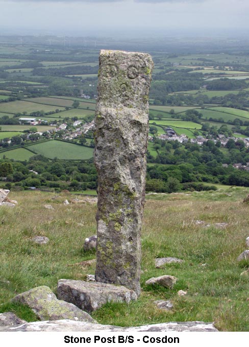
2) Stone Post B/S - Foxes Holt - (SX6403/9255)
3) Water Extraction from Taw Plain - (SX620/924) With
the exception of former mining activity around the eastern side of Taw
Marsh few features give evidence of water being extracted from the area
for power or domestic use, but it has been exploited. In
1878 the Dartmoor and Exeter Water Co proposed damming Taw Marsh to
provide Exeter with drinking water. Some forty years later, the Dartmoor
& District Hydro Electricity Co planned a strategic series of twelve
reservoirs with power stations and canals etc. around the Moor. Taw Marsh
was on the list but apart from Mary Tavy all were refused through local
campaigning. In 1936 South West Utilities Ltd attempted to obtain
permission for both a water supply and hydro scheme. A reservoir covering
around 385 acres would have been involved with a canal system on the
western side of Oke Tor ridge. The House of Lords also rejected this
scheme which, as local tradition has it, was a good thing because during
World War II a number of enemy bombs were dropped into the Marsh. But, the
idea of exploiting Taw Marsh did not go away. In
1957 the North Devon Water Board obtained permission to sink a number of
test bore holes to ascertain the viability of water extraction. This led
to the 1959 North Devon Water Act whereby supplies would be extracted from
the Marsh. However, the project was not without issue. With the widespread
occurrence of granite in the area the water was found to be radioactive
due to the presence of radon; a warning lodged beforehand by objecting
parties. Not
to be distracted, and at a cost of around £52,000, the water company
consequently sunk nine wells and installed an underground aeration tank
for the removal of radon and carbon dioxide with balancing tanks near
Irishman’s Wall. A compensation control house and gauging station was
also constructed, its purpose to ensure the permitted agreed levels of
flow after the allowed 2.5 million gallons of water per day, to a maximum of 60 million
gallons for every 30 days, had been taken were maintained. To complete the
system a treatment works along with a supervisor’s cottage and a two
million gallon underground reservoir were built near the Watchet Hill
moorgate. A monumental stone stands outside the works commemorating Major
Ormsby Allusen, chairman of the North Devon Water Board from 1945 to 1963.
Although credited with bringing “the benefits of a pure and wholesome
supply of piped water to many thousands of houses and farms in the area”
what was not apparent at the time was the water supply yielding too high a
content of aluminium; a fact recognised by subsequent owners South West
Water in the late 1990s which consequently stopped water being drawn from
the Marsh. A
study in the early 1990s revealed how, over the years, the cumulative
result of water extraction had led to groundwater levels, both in the
Marsh and the actual river, being reduced to such an extent that a large
amount of environmental damage had occurred. With concern raised by both
English Nature and the Dartmoor National Park Authority the Environment
Agency was presented with a quandary of improving the natural habitat of
the Marsh whilst maintaining the public water supply. The solution was
granting South West Water permission to extract water from the River Exe
for the period 1997 to 2000 in lieu of not doing so from Taw Marsh. At
that time South West Water insisted on retaining the nine bore holes in
the event they were needed again. However, the 1989 construction of
Roadford Reservoir meant the water supply demand on Taw Marsh would be
replaced thereby negating a need for the agreement. Finally, in 2011, the
Environment Agency revoked the Taw Marsh licence. Following this the
decision was made that removing of the bore hole manhole covers and the
radon treatment works would cause a much greater impact on the marsh than
just simply leaving them in-situ which is what happened. The final chapter
of the Taw Marsh water extraction was that on the 19th of October 2011,
the nine bore holes along with various other structures and pieces of
equipment covering Taw Marsh were put up for auction on the instructions
of South West Water. As
far as the natural environment is concerned there was one last problem -
that of a weir located under Belstone Tor which impeded the progress of
fish trying to reach their spawning grounds in Taw Marsh. In the same
month as the auction the Environment Agency solved this problem by
establishing a 250 metre exclusion zone around the weir and with the help
of some explosives simply blew it up.
(Source:
Extracted and edited from the Legendary Dartmoor website) 4) Walrus Stone/ Belstone Clanger - (SX6212/9239) This large rock which, to me, looks rather like the portion of a bell is situated between the track over Belstone Common and the River Taw. It seems to have been given two names - the Walrus Stone and the Belstone Clanger. It depends at which angle you look at it as to whether you think it's a basking walrus or a section of a large bell. Take a look yourself and see what you think! (Source: Maurice & Internet).
|
| May 2017 - Okehampton Railway Station |
|
1) Halstock Pound - (SX6034/9308) The two Halstock Farms, Higher (SX605/928) and Lower (SX601/936), have been in existence for at least 500 years, as the Forrester's Accounts for the North Quarter for 1505-06 records the dues for the Halstock Farms as "Item for the venvell of Holstock - 2s 6d". The Pound is located at the place referred to as 'Dartmoor Gate', between the two farms and abuts onto the barn, which is known as 'East Bowden'. It would appear that, in the old days, the pound was only ever used for the round-up of Dartmoor Ponies. However, the pound has always been kept in good repair and is now used by the farmer for sheep and cattle, as well as ponies. It would also appear has though it has now been enlarged as Eric Hemery gives it's size as thirty feet by twenty three feet. (Source: Eric Hemery's 'High Dartmoor', pages 862/3). 2) Halstock Chapel - (SX602/937) A short distance beyond the (Halstock) bridge we pass Halstock farmhouse, and make our way through the yard. At the further end of this a track runs S. by the side of a field called Chapel Lands to Halstock Down, reaching it at a point known as Halstock Corner. But instead of following this track we turn L. into the field named, our path lying across it, and close to its northern edge. At the point where the track leaves the farmyard are the remains of some low walls, much overgrown, and close by, in the corner of the field, are the vestiges of an enclosure. It is traditionally reported that Halstock was once a settlement of considerable size, its inhabitants numbering several hundred, and these ruined walls were formerly pointed out as marking a part of its site. The name of the field to which we have referred commemorates the ancient sanctuary referred to in the Forest Perambulation of 1240 as St. Michael's Chapel of Halstock. Little more, however, than its name now remains. Its site is marked by some grass-covered banks, on which grow two storm-stricken thorns, but there are no traces of masonry. The Rev. H. G. Fothergill, a former Rector of Belstone, left some manuscript notes to a work written about 1839, by William Bridges, entitled, Some Account at the Barony and Town at Okehampton, and these were printed in a new edition published in 1889. These notes contain some references to the chapel, of which Mr. Fothergill took measurements. He found it to be nine paces in length and four in width on the inside and says it was enclosed in a sort of court measuring 23 paces by 13 at the western end of which were traces of a belfry or vestry. Some years ago I also carefully measured it, and found it to be 40 feet long, and 24 feet wide; and the court in which it stands 90 feet by 57 feet. The foundations of what Mr. Fothergill supposed to be those of a belfry, or vestry, cover a space 30 feet by 25 feet. These are external measurements. Halstock Chapel, together with the church of Okehampton, belonged to Cowick Priory, in the parish of St. Thomas-by-Exeter, which at its foundation was subordinate to the great abbey of Bec, in Normandy. About the middle of the fifteenth century, on the resignation of the prior, Henry VI applied its revenues to Eton College, but Edward IV transferred the gift to the Abbey of Tavistock. The remains are in the S. part of the field, the site being marked by the two thorns. (Source: extract from William Crossing's 'Crossing's Guide to Dartmoor', page 193). 3) Halstock Bridge - (SX5991/9365) A bridge, built by the tenant at Halstock, now crosses the brook, before which there was a ford here, with a single stone clapper for foot passengers. The clapper is still in its place, but is hidden beneath the soil placed upon it to elevate the roadway. Some years ago I took the measurements of this stone and found it to be 11 feet in length, and 1 foot thick. It was wider at one end than at the other, but about the centre its width was 2 feet. (Source: extract from William Crossing's 'Crossing's Guide to Dartmoor', page 193). 4) Roman Chair - Halstock Cleave - (SX60541/94160)
5)
Fatherford Tramway (part of The Devonshire Heartland Way) - (SX591/945 -
SX602/946) The
‘way’ is a sinuous 45 mile trekking route mostly making use of country
lanes and footpaths. It connects Okehampton via Sampford Courtenay, North
Tawton, Zeal Monachorum, Colebrooke, Yeoford, Crediton, Shobrooke,
Sweetham (Newton St Cyres), Upton Pyne and Brampford Speke with Stoke
Canon. For
the purpose of these notes the path adopts at its western end the route of
the former Fatherford Tramway between the viaduct of that name and
Okehampton Station. When
the Devon and Cornwall Railway (later part of the London & South
Western Railway) was being extended westwards a substantial quarry was
worked at what is believed to be SX 6044 9455 on the west side of the East
Okement. Stone taken from this location was used in constructing some of
the buildings and the bridges and viaducts of which Fatherford would be
one. To enable transportation of the stone to the locations required a
narrow gauge horse-drawn tramway was laid along the valley side to a point
just west of Okehampton Station at Gunn’s depot. It would seem the tramway was constructed in 1870 by or for Robert Relf, the railway contractor. In 1881 approval was given by the L&SWR to lay an addition line to a loading bank adjacent to a new siding at Okehampton. During WW1 the tramway was used to convey pit props cut in the valley to the station. After being disused and neglected the tramway was lifted in 1930. (Source: Bob W.) p.s. Bob D. and I walked the whole length of the Devonshire Heartland Way, in stages, back in 2011 and I can recommend it to anyone who is thinking of walking it as it really does go right through the heart of our beloved County. (Maurice). |
| April 2017- Sharpitor |
| 1)
Leather Tor Farm & Vooga - (SX56722/69778)
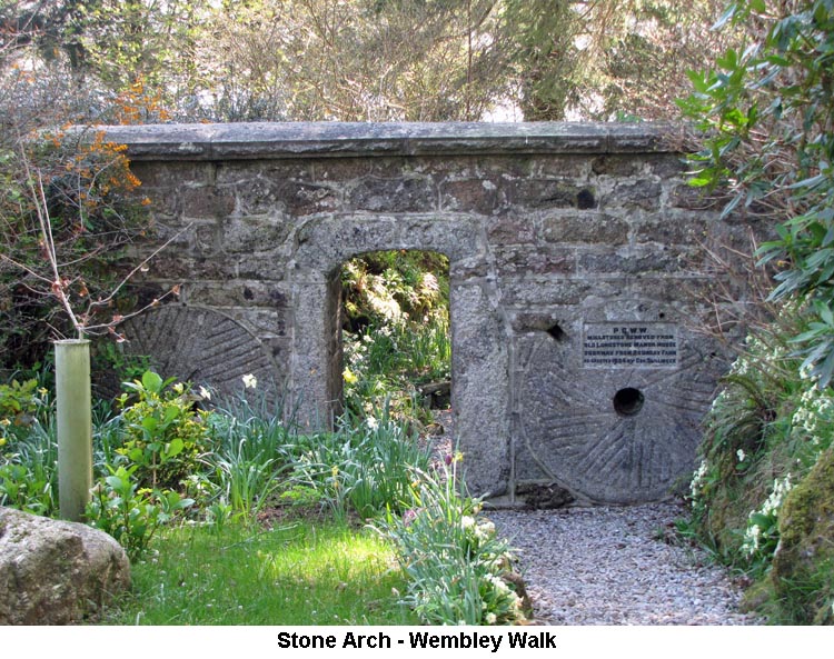
b) Just down the track from the farm, a vooga (SX56717/69773) has been built into the northern bank of the track. The vooga is a cave-like structure that was built by the tin miners in which to store their tools and ingots of tin etc. This one measures 11 feet deep, 3 feet wide and 4 feet high, with a substantial granite lintel across the front which would have supported the doorway. After the tinners' had finished in the area, the vooga was used by the farm for the storage of potatoes, swedes and other similar crops. (Source: Eric Hemery's 'High Dartmoor', pages 123 & 124 and the South West Lakes Trust signboard on site). 2) Peek Hill Plane Crash - (SX562/693) On 19th May 1941, at 2.30 in the morning, a German Junkers 88A bomber was off course and flying over Dartmoor when it struck the ridge of Peek Hill and crashed, with the wreckage ending up far below the ridge towards the banks of the Burrator Reservoir. The plane was one of a group of 36, which formed the entire Küstenfliegergruppe 606 (Coastal Aircraft Group or Marine Patrol Group), on a mission which had set off as a bombing convoy from Lannion Airfield in France. The intended course was to fly over the tip of Cornwall and to bomb a fleet of allied ships which were sailing 120 miles to the north west of Ireland. This was the first mission of this plane's crew in a Junkers, after they had converted from Dornier Do 172 bombers, and possibly they went astray due to unfamiliarity with their new aircraft. The impact of the crash tore off both propellers and sent the plane tumbling down over the hill. Of the four crew inside the plane, none survived the crash and all were buried in the Sheepstor cemetery. The members of the crew were: pilot (Unteroffizer Paul Nowacki), navigator (Oberleutnent Günther Hitschfeld), flight engineer (Unteroffizer Hans Knor) and radio operator (Unteroffizer Joachim Kasten). The bodies have since been exhumed and reburied in the German Military Cemetery at Cannock Chase. (Source: DartmoorCam website). 3) Burrator Discovery Centre - (SX5519/6852) The Burrator Reservoir is one of several reservoirs managed by the South West Lakes Trust and, in 2014, the trust opened their Burrator Discovery Centre, which formed a part of the Burrator Historic and Natural Environment project. The centre is open to the public and provides information not only on the construction and maintenance of the reservoir and it's two dams, but on other local history such as the Princetown Railway, farming, tin mining and other local industries. The grounds around the centre also feature a number of interesting artefacts such as a reservoir boundary stone (inscribed: 'PCWW 1917' - Plymouth Corporation Water Works), a granite trough and a totem pole. The Discovery Centre also provides access to Wembley Walk, of which more information is provided under Item 4 below. (Source: South West Lakes and other websites). 4) Wembley Walk (Burrator Reservoir) - (SX5519/6852)
On completing the purchase of the land within the watershed, the corporation terminated the leases of all the farms within the area. At least one of the farms is now beneath the reservoir, although most of the farms were above the water level but fell well within the water catchment area. The farms were considered to be a great risk to the water supply as effluent and other contaminants would inevitabley find their way into the local brooks and streams which flowed directly into the reservoir. The farms in this area were particularly rich in granite stones which were put to many different uses. It was felt that it would be a great shame if all this local history were to be lost, hence the stones that were deemed to be of the most historic value were rescued and placed along Wembly Walk so that, not only would they be kept secure, they would also be put on display for all to see and enjoy. The walkway contains two arches along its short length, with both having a number of these stones built into them. In between there are a number of granite troughs, millstones, tinners' stamping stones, a lectern and some dated stones. Many of these latter stones date from the 17th century, although some have become quite weathered and are now difficult to decipher. A white-coloured stone shows the date of 1871 and contains the names of R. G. Serpell, Mayor and James King, Chairman of the Plymouth Corporation Water Works. This obviously relates to the agreement between the City of Plymouth and the Water Corporation for the reservior to be built. Another stone is embossed 'M. L. 1868'. This refers to Massey Lopes who was a local landowner and architect. He arranged for many of the local farm houses and buildings to be restored and would always incorporate a stone showing his initials and date within the reconstruction. (Source: Eric Hemery's 'High Dartmoor', page 114). (N.B. These notes were rewritten in January 2021 as the original notes had somehow disappeared before a back-up was taken). |
| March 2017 - Yellowmeade Farm Entrance |
| 1)
Foggintor Mission Hall - (SX56714/75019)
Beside the road and opposite the entrance to the Yellowmeade Farm track can be seen the outline ruins of the old Foggintor Mission Hall. The hall was built in 1887 to be used for non-denominational worship for the workers of Foggintor Quarry and locals living nearby. Alongside the hall there was an adjoining house for use by the Caretaker. In 1895, the local parish councillor complained to the Walkhampton Parish Council that there were about 60 children living in and around the quarry area who were receiving no education and requested that the Council set up a school for them. It was decided that the Mission Hall would provide suitable premises and a temporary lease was obtained. A teacher was appointed and the new school opened with 41 pupils in August 1896. However, the building was not ideal due to its exposed location and children would often arrive at the school so wet and cold that they had to be sent straight home again. Temporary permission for the school lapsed in 1897 and it had to be closed down. However, it was shortly able to reopen again and became very popular, with pupil numbers rising to 95 by the year 1903. Overcrowding then became an issue and, in 1912, the County Council decided that it would provide a larger and more suitable premises. The school moved out of the Mission Hall premises in September 1912 and used the Foggintor Quarry Chapel as a temporary classroom until the new purpose built school was ready for use at the site where the Four Winds car park now stands. The Mission Hall and Caretaker's house were demolished in 1965. (Source: varous websties). 2) Foggintor Quarry - (SX566/736)
3) Yes Tor Farm - (SX56294/72788)
4) Ward Bridge - (SX54197/72018)
(N.B. These notes were rewritten in January 2021 as the original notes had somehow disappeared before a back-up was taken). |
| February 2017 - Willsworthy |
|
1) Willsworthy
Boundary Stone (M/P/B) - (SX52197/83330)
The modern looking triangular boundary stone on the Willsworthy Range is inscribed with the letters 'M', 'P' and 'B' on each of it's faces. These represent the boundaries of the parishes of Mary Tavy, Peter Tavy and Brentor. In 1987, there was a major restructure of the parish boundaries in the Borough of West Devon and this saw the creation of four new parishes and an adjustment to the alignment of several others. The original of this boundary stone stood at the point (SX518/836) where the three parishes originally met but this, unfortunately, was one of two stones that were destroyed by the American Forces during World War II. This replacement stone was erected at the new junction of the three parishes at some point during the year of 1987. (Source: Dave Brewer's 'Dartmoor Boundary Markers', pages 187 to 190). 2) Wheal Jewel Leat & Reservoir - (SX522/813) In
1936, as a result of other hydro-electric projects undertaken around
Dartmoor towards the end of the nineteenth century, it was decided to
recondition the old Reddaford leat and build a reservoir beside the old
Wheal Jewel workings which had opened for tin in 1865 on the site of
earlier workings and closed in 1911. Constructed in the early part
of the nineteenth century Reddaford leat supplied pounds associated with
the water powered machinery of the big Mary Tavy mines of Wheal Jewel,
Wheal Betsy and Wheal Friendship. It drew water from the River Tavy,
beneath Ger Tor, and had a fall of only 26 feet over its 4½ miles length. This
new ‘S’ shaped reservoir was designed to hold 6,000,000¹
gallons of water and is also supplemented by a feed from the Wheal
Friendship leat which is taken off the Walla Brook below Doe Tor. From the
screen house at the reservoir’s southern end, water is carried by a 3 ft
6 inch diameter pipe through a fall of 560 feet for two miles to reach the
Mary Tavy turbines on the old South Friendship mine site where it drives
alternators connected to the National Grid. The
scheme came into operation in August 1937 becoming part of the
nationalised system in 1948. It was subsequently controlled by the Central
Electricity Generating Board, but is currently under the custodianship of
South West Water and referred to as their Number Two Water Plant². The
leats across Kingsett Down supported an extensive industry, which in its
hey-day comprised many mines named after families and mine captains with
deep shafts and seventeen water wheels of differing size at Wheal
Friendship working machinery to process ore and pump away underground
water. Wheal Friendship near Mary Tavy was, at one time, the largest
copper mine in the world covering an area of 30 acres, and dates back to
1714. When first worked it dealt with lead, then copper and small amounts
of silver during periods of fluctuating viability. In its latter years, up
to 1924, arsenic became its main product and source of income. One of its
shafts reached a depth of 220 fathoms at a time when copper was being
extracted in 1875. Of the visible remnants from this mining period the most significant is the restored engine house of Wheal Betsy (also known as Prince Arthur Mine and North Wheal Friendship) at SX5101/8140, above the Cholwell Brook, which closed in 1877. There is also a three-spanned clapper called Horndon Down Bridge over the dry Wheal Friendship Mine leat at SX 52237 81728. (References: Wm Crossing, Helen Harris, Eric Hemery & South West Water). Notes: ¹Harris and Hemery quote this figure, but South West Water give 16,000,000 in thier Mary Tavy Power Station leaflet. ²South West Water mention about doubling their energy production from renewable resources by 2015 and a longer term plan to obtain 50% of their energy needs from renewable sources by 2050. Reference the above leaflet. I have been unable to find any recent information as to the operation of this station. 3) Gibbet Hill - (SX50316/81159) Gibbet
Hill is the highest point on Black Down (1,158 feet) and mentioned by
William Crossing in 'One Hundred Years on Dartmoor' as the scene, so
stories said, of the death by burning of the wicked Lady Mary Howard of
Fitzford House. He also refers to tales of unfortunate wretches
being confined in an iron cage and left to die. It
was the custom some two hundred years ago to hang felons in an iron cage
suspended from a gibbet until starvation and carrion crows disposed of
them; such policy being undertaken to discourage the crimes of highwaymen
that operated on the Tavistock to Okehampton road. The last local brigand
of notoriety, Rawley, had eluded capture by hiding in a mineshaft at Wheal
Betsy until justice triumphed in the early part of the eighteen
hundreds. There was one case told of a male occupant existing (in
the cage) for some time due to country people supplying him with food and
he being ravenous enough to eat candles when folk returning home from
market had nothing better to offer him. Apparently a moor gate, known as Iron Cage Gate, used to stand at the end of Burn Lane on Black Down (possibly at SX49154/81671) where prisoners were kept in cages until hanged at the top of the hill. On the north-west side of the summit are some workings known as Gibbet Hill Pits (Blackdown Mine), whilst on the southern slopes two fenced off shafts can be found. These are the remains of unsuccessful trials for tin dating from about 1870. There is also a record of the Duchy requiring payment of a rental in 1862. (References: Wm Crossing, Helen Harris, Eric Hemery and the Internet). 4) Iron Cage Gate - (SX48685/81093) I was not sure about the position of Iron Cage Gate and have continued to seek information that might clarify its location. William Crossing referred to it as situated at the end of Burn Lane and Mary Warne wrote of it near a gate by the cattle grid on the Brentor Road. On my 1:10,000 Memory Map version of Streetview, Burn Lane is only named for some of its length but it would seem likely that it forms a junction with Station Road at SX 48685 81093 where a cattle grid is clearly visible on Google Earth. It is from this corner that both Crossing and Hemery give The Dartmoor Path as continuing its route across Black Down to the Rattle Brook making it more than likely to be the location of the gate. Along its way this path crosses the Lych Way at Forstall Cross, which is not marked on any of my OS maps. Crossing speculates in his 'Ancient Stone Crosses' as to whether a cross ever existed there and mentions a boundary stone marking the spot. As to how its name came about there is no explanation. From the detail I have I can only estimate that the crossing point of these two paths falls between the two leats at approximately SX 52610 83180 which is close to where the western end of the military rifle butts are located. (References: Wm Crossing, Eric Hemery & Mary Warne).
|
| January 2017 - South Brent |
|
1) Lydia Bridge -
(SX69575/60673)
Sabine Baring-Gould once collected a number of folk songs from Robert Hard, a stone-breaker, who lived at Lydia Bridge. This was arranged through the local vicar who invited them both into his drawing room and the songs were noted down as they were being played on the Vicar's piano. The local Miller, John Helmore, also provided Baring-Gould with some more folk songs and the set was published in his 'Songs of the West', in 1890. The picturesque mill on the right bank below the bridge was, at the end of the 20th Century, a canvas mill owned jointly by William Crossing's father, Joseph, and Henry Hurrell, grandfather of the naturalist H. G. Hurrell. Joseph persuaded Henry to take his son, William, into the business but the call of the moor was too strong and the exasperated Hurrell insisted on a premature termination of the moor-dreaming William's apprenticeship. (Source: Eric Hemery's 'High Dartmoor', pages 257 & 329). 2) Ball Gate - (SX67031/61300)
|