|
|
|
|
|
|
|
|
|
Research Notes 2013
| December 2013 - Tolchmoor Gate |
| 1)
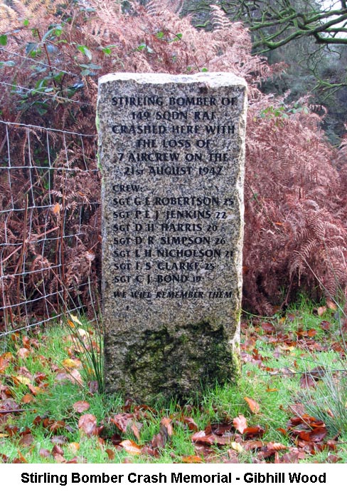
Stirling Bomber Crash Memorial Stone - (SX5943/5987)
Please see updated entry in the Research Notes from the walk in November 2017.
|
| November 2013 - Fernworthy Forest |
| 1)
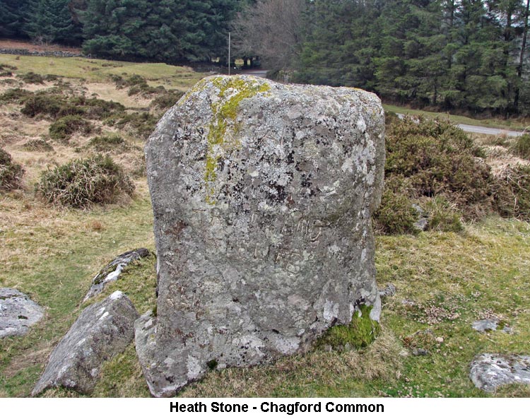
The Heath Stone - (SX67130/83760)
Jeremy Butler reckons that because of its location, the OS Heath Stone would have been a useless guide/bond mark, and Crossing attempts to place it elsewhere in consideration of ancient place names and possible corruptions. Eric Hemery disagrees with both of them saying it is in the right spot! It is difficult to get an impression of the lay of the land without removing the forest of Fernworthy and the reservoir from the scene. One probable candidate for the Heath Stone could be a 6 foot pillar at the south-western end of the Hurston Ridge double stone row, but having read extracts from the Historical Documents section of Samuel Rowe’s “Perambulation of Dartmoor” my thoughts are still unresolved. The following I’ve put together and abbreviated somewhat from his book. It is probable that the Forest Perambulators of 1240 (an undertaking requested by Henry III) included the Heath Stone in their survey, but the problem is in identification. Two well known points in that quarter, and on either side of it, are: Thurlestone and Furnum Regis. The surveyors’ path between these two locations is (from Thurlestone) to Wotesbrokeslakefote (Woodlake or Hugh [Hew] Lake Foot) where it enters the Tyng, to Heigheston (Hengheston), to Langestone (Yessetone), to the turbaries of Alberysheved (Aberesheved) and thence along the Wallebroke (North Walla Brook?) to Furnum Regis. In 1609 a similar Perambulation was undertaken for James I. This time the surveyors’ bond marks from Thurleston (recorded now as Waterdontorr) are: to Wotesbrookelake foote which falleth into Teynge (thought to be what is now called Whoodelake) to Hingeston or Highstone near Ffernworthie Hedges (location unknown) to Yeston or Geston commonly called Hethstone then through a fennye place now called Turfhill (formerly known as Albereeheved [sic]) to a place called Kinge’s Oven (formerly Furnum Regis). This is a new one to me, but in 1786 a survey was undertaken for the then Prince of Wales, later George IV, to establish his possessions as parcel to the Duchy of Cornwall. On this occasion the bond marks are much reduced and begin one place back from Thurlestone i.e. Hound-torr. The line then goes direct to Whodelake foot where it falls into the Teigne thence to Heighstone or Langstone (near the corner of Fernworthy Hedge) to Hethstone and direct to King’s Oven. It is not easy to place all the Perambulation markers with certainty, but in general they would have surely been significant landmarks and I do so love the old pronunciations and spellings. So much conjecture and so much lost history, will we ever know? (Source: Bob W's research).
|
| October 2013 - Trendlebere Down |
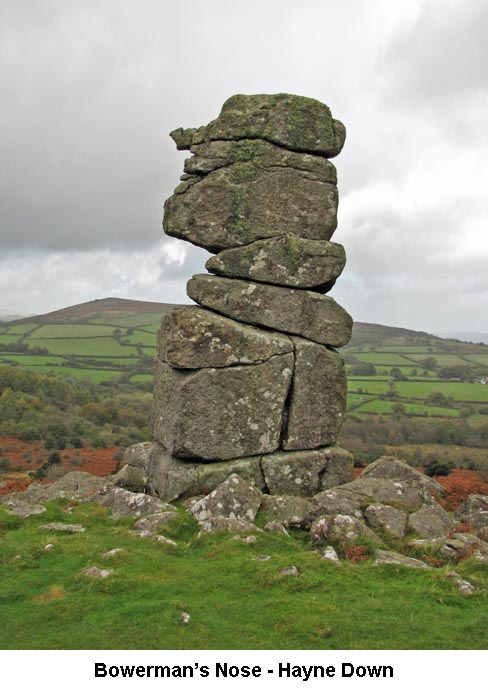 1)
Bowerman's Nose - (SX7410/8047) 1)
Bowerman's Nose - (SX7410/8047)The general consensus is that Bowerman's Nose is named after a local resident, John Bowerman. Not a lot is known about him except that he was buried at North Tawton in 1663, which means the naming of the rock is fairly recent in Dartmoor terms. (Source: Eric Hemery's: High Dartmoor - page 729). 2) Swallerton Gate - (Grid Ref: SX7390/7914) The house was, until 1840, a public house called the Hound Tor Inn. This was a cider house that was frequented by travellers in the early days of the wool trade. The thatched house, which is now a private dwelling, is of two different ages. The lower level being much older than the taller, Northern end, which is a Victorian addition. Water used to be carried to the house by a pot-water leat, supplied by a nearby spring, which still flows today. The origins of the cross head built into the roadside wall are not known, although it's recent history is interesting. According to the present owner it was amongst a pile of rubble about to be placed as hardcore for the flooring of the extension, previously used to house bullocks and now a holiday cottage. As the stone was being moved, a voice called over the garden wall, informing the owner that what he was holding was the head of a mediaeval cross. The knowledgeable stranger was none other than Harry Starkey and his timely intervention resulted in the cross being saved and used in the construction of the garden wall, rather than lost to posterity. The roadside face has an incised cross in the centre of its head. (Source: Internet: dartmoor-crosses.org.uk).
|
| September 2013 - Postbridge |
| 1) Pizwell
Clapper Bridge? - (SX6697/7768)
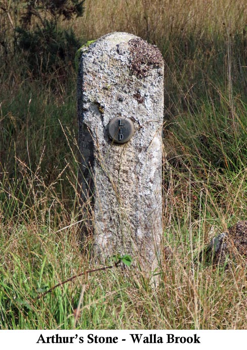
2) Arthur's Stone - (SX6692/7873)
Note: On page 77 of his book, Dartmoor Boundary Markers, Dave Brewer gives the Grid Reference of Arthur's Stone as SX6715/7720. This places it about a mile further downstream on the Walla Brook. I think he has got it confused with another boundary stone that has been sited in this place for many more years and is marked on the current Ordnance Survey map. We were intending to visit this other stone on our September 2023 walk, but the ground was too wet and boggy for us to be able to reach it on the day.
|
| August 2013 (2) - Smeardon Down - Peter Tavy |
|
1) Turf
House - (Grid Ref: SX5692/8083) The ruined structure, associated with Walkham Head Peat Works, lies on the slopes east of Lynch Tor; above the River Walkham’s right bank and south of a feeder known as Ninny Lake. An 1879 publication (Handbook for Devon) mentions eleven upright blocks being visible, but during his rambles William Crossing recalls seeing a few standing. Today only one granite pillar remains vertical as testament to the uprights that once stood as roof supports. No illustration or photograph has come to light to show what the building looked like although evidence of walls can be traced. In the summer months of the building’s heyday (most likely the early to mid eighteen hundreds) considerable quantities of peat were cut in the area. Instead of all the turves being removed when dry, a stock was placed in the ‘House’ and brought down as required for the Mary Tavy mines. In particular these would have been Wheal Friendship (tin, copper, arsenic, lead and iron) which occupied the greater part of Mary Tavy village stretching from the River Tavy to nearly a mile westwards, and Wheal Betsy (silver and lead) on the Cholwell Brook under Black Down. Black Lane (north) was used to convey the peat by packhorse. It enters the moor at Bagga Tor Gate and runs for a short distance on the line of the Lych Path before swinging northwards by the farm enclosures to reach a location called Brook’s Head (otherwise known as Outer or Easter Red Lake). As it passes under Lynch Tor a branch turns off right going over the ridge and descends to the disused peat works. Although peat was used into the 1840’s it did not have a high enough calorific value so in later years coal took over. It is probable that the function of Turf House declined following this transition although the Walkham Head turf-ties were reworked on a smaller scale around 1880. (Source: William Crossing's Guide, One Hundred Years & Dartmoor Worker; Harris's Industrial Archaeology of Dartmoor; Internet).
|
| August 2013 (1) - Four Winds, Merrivale |
| 1) Four
Winds Car Park - (Grid Ref: SX561/749)
The Four Winds Car Park was originally the site of the Walkhampton Foggintor School - which came about after the 1902 Education Act as it was considered that no suitable building existed in the area. Construction commenced in 1914 and it was opened on 19th April 1915 to take pupils from the Foggintor, Rundlestone and Merrivale areas. It had separate entrances for boys and girls, each with cloakrooms and toilets, and two classrooms, one for infants and one for 11 to 14-year-olds. There were separate playgrounds for boys and girls behind the school buildings with a house and garden behind the boys' and a coke store and playing field behind the girls'. The school closed in 1936 with pupils transferring to Princetown. The property was bought in 1938 by a Dr Adamson who might possibly be responsible for the name Four Winds. When he left there were plans to convert the site for other uses but they all came to nothing. Being viewed as a "grave disfigurement" in a stretch of completely open moorland it was demolished in the spring of 1964 by ten boys from the Northbrook Approved School under the care of two school masters who were also building instructors. The rubble was used for the construction of a new section of road at Devil's Elbow. (Source: Supplied by Bob W. from a book by Dave Brewer's wife).
The Touch Stone, erected alongside the footpath through the Dartmoor Prison Farmland to the north of the B3357, was the idea of John Powls who was, at the time, 'Poet in Residence' to the Dartmoor National Park. The stone was sourced from the Prison Quarry and inscribed by Kevin Andrews of Polzeath for the Millennium. The stone was erected on the Summer Solstice in 1999 and dedicated on the Winter Solstice of the same year. The wording of the poem inscribed on the stone is: Inspiring / This stone touching / Open moor and sky / Granite land mark / Raised to stand / For all times As one time; / Now, then and ever / In love and beauty / Our story is a book / Always open / At the centre / Half of experiences / Half of / Un-named hopes. / John Powls 1999. (Source: Internet). 3) Fice's Well - (Grid Ref: SX5773/7587)
Back in the 16th Century, which was long before there were any roads as we know them now and before Princetown and the Prison were built, the moor was a lot more open and wilder with perhaps just the hint of a track which ran across the moor for travellers between Tavistock and Exeter. In 1568, John Fitz and his wife were travelling across the moor on this track when they became disorientated, perhaps when travelling through a Dartmoor mist, strayed off the track and became lost. They just happened to stop by the well and, feeling thristy, drank from the water in the well. This instantly revived them and they quickly picked up their track again and went on their way. John Fitz was so grateful for the water in the well that he arranged for the granite surround to be constructed to protect the well and had his initials and date (IF 1568) inscribed in the lintel. (The letter 'I' often replaced 'J' in the old English language) Dartmoor legend also has it that the water of the well acts as a curative for eye complaints. Mothers would take their children to bath their eyes in the well water and one old man was so convinced by its powers that he would make an annual pilgrimage to the well and carry away as much water as he could manage in order to treat himself throughout the year. Source: Eric Hemery - 'High Dartmoor' pages 380-381). |
| July 2013 - Fernworthy Forest |
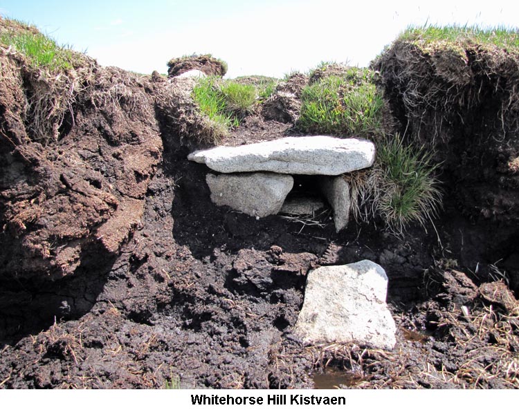
| 1) Whitehorse Hill
Kistvaen - (Grid Ref: SX6173/8548)
2) Teignhead Farm - (Grid Ref: SX635/843) In 1805, a Matthew Crawford arrived on Dartmoor from Ireland and applied to lease some farmland from the Duchy of Cornwall. After two unsuccessful attempts he teamed up with Lieutenant Colonel Richard Fleming, from Surrey, and in 1808 they took out a 99 year lease on 1551 acres of land in the Teignhead area. A condition of the lease was that they would enclose the area of land and establish two farmsteads within 10 years from the start of the lease. The two farms were Teignhead Farm (SX635/843) and Manga Farm (SX639/848). Although the two farms were built within the time limit, they only managed to enclose 941 acres, thus qualifying for a rebate on their rent of £58.3s.11d per annum. The tenancy was then sold on to Mr Plowden Presland, from Middlesex, in 1818. The farm changed hands many times up to the last tenant, George Hutchings, who stayed at the farm until he was evacuated by the War Department, in November 1942, as they wished to take over the farm and surrounding land for training British and American Troops. Although the land was leased again after the war, no-one ever lived in the house again and it was demolished by contractors in 1971. (Source: Dartmoor Forest Farms - Elisabeth Stanbrook - Pages 11 - 41).
|
| June 2013 - Combestone Tor |
|
1) Stacombe's Telling
Place
-
(Grid Ref: SX669/710)
The area around Horn's Cross is known locally as Stacombe's (or Stascombe's) Telling-Place. This originated from a local farmer, by the name of Staddicombe, who used to pasture his sheep in the area. He would round up his sheep at this place on a regular basis for the purpose of Counting or ‘Telling’ them. (Source: Ancient Stone Crosses of Dartmoor - William Crossing - Page 103). 2) Boundary Stones a) PUDC - Paignton Urban District Council - Water catchment area for Venford Reservoir. (Source: Dartmoor Boundary Markers - Dave Brewer). b) RDH - Richard Dawson of Holne - Marking boundary of Holne Parish. (Source: Dartmoor Boundary Markers - Dave Brewer). b) H - Holne - Marking boundary of Holne Parish. (Source: Dartmoor Boundary Markers - Dave Brewer). D) B - Buckfastleigh - Marking boundary of Buckfastleigh Parish. (Source: Dartmoor Boundary Markers - Dave Brewer). 3) Puper's Hill - (Grid Ref: SX672/673) The word 'Pupers' is derived from 'Pipers', a Dartmoor tradition where those people who piped or danced on a Sunday would be turned to stone. This tradition also applies to the Dancers and the Nine Maidens Stone Circles. (Source: High Dartmoor - Eric Hemery - Page 307).
|
| May 2013 - Harford Moor Gate |
|
1) Concrete &
Metal Structure beside the River Erme - (Grid Ref: SX63975/59900)
In the 1920s and 1930s there was a sort of country club at Bullaven, which is a little to the north of Harford Church on the opposite side of the river to Tristis Rock. There was a swimming pool there among the various facilities, and this was the water intake for the pool and perhaps other uses. The country club burnt down at some point during the war. It is generally supposed that it was not entirely accidental. The place always was a bit unsalubrious, and it is said that it was the sort of establishment where men went with someone else’s wife. They had a lookout at the bottom of the drive to raise an alarm if the police were coming, so that they could serve drinks after hours. It was originally a farm house that was extended. After the war it changed hands and was made back into a farm, with a 1950s bungalow as the farm house. (Source: Bob W's Research).
|
| April 2013 - Bennet's Cross - (Grid Ref: SX68012/81638) |
|
1) Golden Dagger Mine
- (Grid Ref:SX684/800) The name of the Golden Dagger Mine is thought to be named after 'Dagger Hill' where the main lodes of ore were mined. Golden Dagger Mine was first recorded in the 1850's, 20 years earlier than the discovery of a jewel-encrusted dagger in a barrow on nearby Hameldown. It could well be a previously discovered similar dagger that gave it the name. The concrete foundations we saw supported the machinery used to drive the Buddle Sweeps and were driven by a water-wheel. (Source: Tin Mines and Miners of Dartmoor - Tom Greeves - Pages 45-80). 2) Boundary Stone near Grimspound - (Grid Ref: SX6965/8098) The 'B / WB' Boundary Stone we came across by the road below Grimspound was a joint stone between the Parish of North Bovey (B) and the Headland Warren Boundary (WB). Similarly, the two boundary stones close to King Tor both had a 'B' inscribed for the North Bovey boundary. (Source: Dartmoor Boundary Markers - Dave Brewer - Page 74). 3) Boundary Stone near Bennet's Cross - (Grid Ref: SX6800/8167) The Boundary Stone just across the road from Bennet's Cross was originally set up by the local Turnpike Trust and is inscribed 'Chagford / North Bovey' (not now legible). (Source: Dartmoor Boundary Markers - Dave Brewer - Pages 73/4).
|
| March 2013 - Merrivale |
|
1) Moortown Venville
Stone -
(Grid Ref: SX52387/73848)
Another of the Venville Tenants' duties was to attend the Dartmoor drifts which were held four times a year. There would normally be three drifts in the summer and one in winter. On the morning of a drift the forest reeve would send his messengers out onto the moor, at 2.00am, to blow their horns from the surrounding tors and other high places to summon the tenants to the drift. Some of the messengers would blow their horn into a Venville stone, which was thought to amplify the sound and make it easier for them to be heard. No prior notice was given of the drifts in order that anyone who was illegally pasturing livestock on the moor would not have time to remove them and would be caught out. During the drift, all the cattle and ponies would be rounded up and herded down to the local pound where the animals would be identified for each Venville farmer and released. The remaining animals could be reclaimed by their owners on paying the appropriate fine. Any animals not claimed after 21 days would automatically become the property of the Duchy, who would then be able to sell the animals and keep the proceeds. (Source: William Crossing 'Crossing's Guide to Dartmoor'- Pages 38-39 & Legendary Dartmoor website).
|