|
|
|
|
|
|
|
|
|
Research Notes 2020
| December 2020 - Princetown |
1) Crazywell Farm - (SX5809/7006)
At the western approach to the farmyard there are two gateposts still standing, the northern of which was once a portion of a fine granite cross shaft. All that remains now is 3 feet 2 inches of the shaft showing above ground and it is not known what happened to the upper section of the shaft or the cross head. It is also not known where the cross would have originally stood, although it is very close to the line of crosses, Newleycombe, Crazywell and Cross Gate, which are all very close to the route of the branch of the Abbot's Way, which runs from from Buckfast Abbey to Plympton Priory. Further to the west, there are two examples of a sheep creep set into the base of the boundary wall. These are low square openings in the wall which were big enough to allow sheep to pass through, but small enough to prevent larger animals, like cows, from leaving the field. The farm was abandoned early in the 1900's, when the Burrator Reservoir was first built, to avoid any contamination to the water supply as the farm fell within the water catchment area. (Source: Eric Hemery's 'High Dartmoor' page 141). 2) Hart Tor Rifle Range - (SX5815/7212) The notes on the Hart Tor Rifle Range have now been updated following our visit on the December 2020 walk. As well as finding 4, and a possible 5th, further distance marker posts, we also came across a range communications post very close to the target base.
|
| October 2020 - Harford Moor Gate |
|
1) Resin Cross - Redlake Tramway Track - (SX6502/6260)
2) Butter Brook Reservoir - (SX645/592)
In 1994, South West Water closed the nearby Broomhill water treatment works which made this reservoir redundant. The Authority did make an attempt, in 2015, to auction off the leasehold of the site, perhaps to someone who would like to develop the reservoir for fishing or as a moorland retreat. However, the Authority placed so many conditions on any prospective leaseholder that there was little interest on paying the guide price of £40k for a 150 year lease. Among the conditions were that the leaseholder would have to keep the site, including the boundary fence and surrounding land in good repair, allow access for inspection to South West Water employees as required and no multiple overnight occupancy would be allowed. Moreover, the Authority reserved the right to re-use the reservoir in times of drought and to make regular inspections of the site and associated underground pipework. The Authority would also retain the right to reclaim 50% of the inspection and maintenance costs from the leaseholder. It is not surprising that there was very little interest in anyone wanting to take on the leasehold and the reservoir continues to remain under the control of the Water Authority. (Source: Legendary Dartmoor website).
|
| September (2) 2020 - Hexworthy |
|
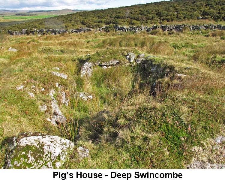
1) Pig's House - Deep Swincombe - (SX6425/7191)
Sometime after being abandoned by the tinners the building was restored and given a new roof. It was then used by a herdsman whilst attending his livestock out on the moor. The granite trough may well have been instituted by the herdsman for his animals, rather than it being in earlier use by the tinners. It is not known when or why the Pig's House acquired its name, but it certainly fits with the herdsman's occupation. (Source: Eric Hemery 'High Dartmoor', page 351). 2) John Bishop's House - (SX6412/7259)
The empty building gradually fell into decline until, in 1969, a film producer, John King, used it in a film called 'The Stallion'. In order to give it an authentic look, the film company made some repairs to the house by giving it an asbestos roof and a new door. After the making of the film it became derelict again and only a few years later the new roof had caved in, the timbers supporting the upper floor had rotted away and the back wall fell down. The Dartmoor National Park Authority has done some work to preserve the prominent entrance porch, but it's a great shame to see the rest of the building falling into further decay year on year. (Source: Legendary Dartmoor website).
|
| September (1) 2020 - Meldon Reservoir Car Park |
|
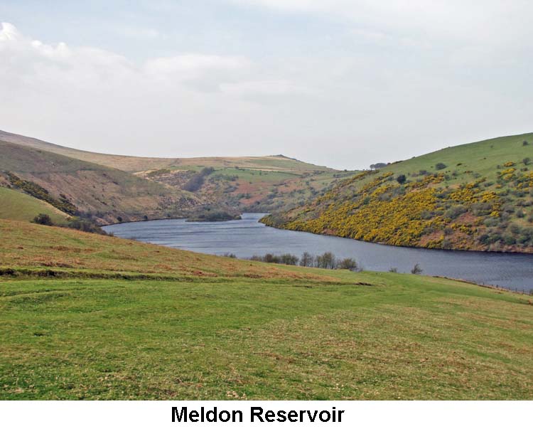
1) Meldon Reservoir Footpath (Western side) - (SX5612/9174 - SX5549/9060)
This arrangement seemed to work well for many years but, in 2011, negotiations between the DNP and the land owner broke down and the DNP ceased the payment completely. The land owner felt he had no option but to withdraw his permission for the use of his land as a footpath. He put up a sign to notify people of this fact, both on the gate opposite the car park and on the bridge at the far end of the reservoir. He also barricaded up the bridge to prevent walkers from ignoring his sign and just crossing it anyway. At the end of our 4th September 2020 walk, a man was coming out of the field beside the car park with his dog in a John Deere Gator. I got talking with him and he happened to mention that he is the land owner of all the fields in the area. When I asked about the footpath, he confirmed that he had closed it after his negotiations with the DNP had broken down. He told me that if he were to open up the footpath again now he would need public liability insurance to cover him against claims from the public who might sustain an injury whilst walking on his land. This would cost him £3,000 per year from which he, of course, would see no benefit. He told me the DNP are no longer willing to reimburse him for his costs so he, obviously, can see no advantage in reopening the footpath. The only option open to walkers now is to cross the West Okement on another footbridge further upriver and ascend the hill to pick up the bridle path that runs from the direction of Sourton Tors to the lane that leads up to the Reservoir car park. In all probability the loss of the footpath has happened as a result of budget cuts within the DNP, but the real shame of it is that it's Dartmoor walkers, like us, who end up being the real losers. (Source: Maurice's conversation with the owner of the land around the Meldon Reservoir). 2) Okehampton Firing Range Whilst walking beside the Red-a-ven Brook on the walk we saw a farmer on his quad bike, and with a dog, rounding up his sheep from around the base of Yes Tor and moving them over to near West Mill Tor. I wondered whether this was in preparation for some days of firing practise by the Military on the Okehampton Range for the next few days. At the end of the walk, I got talking to the land owner of the ground around the reservoir (see 1 above), and I asked him if he had just come back from rounding up his sheep on the moor. He said that it wasn't him but must have been one of his neighbouring farmers. I then asked him whether I was right in thinking that farmers had to take their animals off the moor prior to firing practice taking place but he said that they didn't have to remove the animals completely, just move them to another area away from where the firing was due to take place. He also said that the Okehampton Range was little used these days, compared to how it used to be. At one time this range was used for all the heavy equipment, with tanks firing shells that would make really large craters in the ground wherever they hit. Generally speaking now the only part of the range they use is the area to the south of Row Tor and between the West and East Mill Tors. (Source: Maurice's conversation with the owner of the land around the Meldon Reservoir).
|
| July 2020 - South Zeal |
| 1)
Big Whit Hill Cross (Recumbent) - (SX6296/9037)
Information about the Big Whit Hill Cross can be found on our Dartmoor Crosses website.
|
| May 2020 - No Walk due to 'Coronavirus Lockdown' |
| 1)
Tavistock / Ashburton Packhorse Track - (SX4844/7456 - SX7560/6989)
Leaving
Tavistock at Vigo Bridge (SX484/746) the way to Whitchurch Down is
followed, which in turn is crossed to reach Moortown via Quarry Lane and
then onward over Whitchurch Common. From here the track went formerly
north around Vixen Tor and into the valley of the Walkham to cross said
river at Long Ash Ford and clapper thereby gaining access to Long Ash
Common where the Merrivale Antiquities[1]
are. This long forgotten section is not passable in its entirety and the
route now goes via Merrivale Bridge. Leaving the antiquities
behind, and after fording Pila Brook, the track continued through the
enclosures of Yellowmead Farm[2]
before skirting the southwest flank of North Hessary and crossing the
area later to develop into Princetown. Following
what is now called Peat Cot road, the future sites of both Tor Royal and
Bull Park are then encountered and the track (later christened Conchies
Road) crosses the broad area of rising ground named Royal Hill, leading
to what Tyrwitt would call Higher Swincombe and the ford across the
river, also spanned by Fairy Bridge. From here there was a choice of
going though Hexworthy or bypassing it (the original green track not a
right-of-way) to traverse Saddle Bridge, pass Combestone Tor and Venford
Reservoir (although the old route crossed in Wennaford Bottom, more or
less in the middle of the reservoir; a single-arched structure in place
before the construction of the dam) to reach or even bypass Holne
village. The final leg goes via Gallant Le Bower, Holne Bridge, Hele
Cross and Holne Turn to join the Buckland Road and enter Ashburton over
Great Bridge: according to Hemery a total distance of 19½ miles. The locations of four TA guide stones[3] included on Maurice’s “Devon Marker Stones” site were plotted onto an OS 1:25,000 map. These “improved” stones, which were accordingly sponsored by Plymouth Corporation in 1669 for the guidance of travellers passing between Plymouth and Exon (as a section of the trans Dartmoor packhorse track shared this stretch of the moor), tend to align with the Merivale Bridge route as opposed to the ancient one accessing the ford and clapper in Walkham Valley. As sketch mapped by Hemery these stones are followed, except for one Maurice photographed being used as part of a clapper bridge over the Wheal Emma Leat on the Sandy Way. This stone is a significant distance from the TA Track as described by Hemery, in fact some 8/10 mile south west of its nearest point and could almost call into question whether he has got his facts right and if the Sandy Way might have had a role to play in part of the Tavistock to Ashburton alignment! Notes: 1. The cross on Whitchurch Down, together with the Windypost and the 10' 5" high menhir near the Long Ash enclosures on Merrivale, all seem to mark the original route as they are on a line with it. 2. These, along with Foggintor Quarry, did not exist at the time. 3. Some of the missing “TA” stones have been discovered elsewhere in use as gateposts or lintels. Those that remain in situ tend to be found mostly in the North Hessary to Merrivale Bridge region, with one located on the original track as a gatepost at Higher Swincombe.
|
| March 2020 - Scout Hut (Sheepstor) |
|
1) Thrushelcombe Brook Mining Remains - (SX5918/6765) Right beside the track coming down from Eylesbarrow to Ditsworthy Warren House there are some interesting mining remains which probably once were part of the extensive Eylesbarrow mining operation, centred on the main mine about ½ mile to the north east. Beside the track there is an horizontal underground flue of about 70 feet in length with the top being covered in large flat stones. The main purpose of the flue was to trap tin dust which otherwise might have escaped into the atmosphere. At the north east end of the flue was a chimney stack, but this has long since disappeared. Below the flue are the ruins of a smelting house which had a wheel pit, at its south western end, which once housed a 16 foot water-wheel, but the pit has now been filled by the wall stones falling in and bringing it up level with the surrounding ground. There are a few large squared granite blocks on each side of the smelting house, the purpose of which is unknown to me. Set back against the bank are three substantial pillars which were used as the main supports for a stamping mill. (Source: The Field Archaeology of Dartmoor article (Bob W.)). 2) Ditsworthy Warren House - (SX5843/6629)
The nets used to trap the rabbits were of two lengths, 50 and 100 yards long. These would be stretched out between posts and pegged to the ground. The men and dogs would then start the drive to flush the rabbits out. As was usual at that time, the nets were maintained and repaired by the warrener's wife. In the early days, the rabbits were cleaned and taken by pack-horse by William for sale at Plymouth and Devonport - a return journey of 28 miles. Later, the journey was eased by the use of a horse and cart. When the railway reached Yelverton and Dousland, the rabbits were transferred onto trains for onward transmission. The warren house is now owned by the Maristow Estate and leased to the Admiralty for use as a base and accommodation for recruits when out training on the moor. The house is also Grade II listed. Round the side of the house is an area know as Kennel Court. This is where the warrener's dogs would have been kept and three recesses are set back into the stone walls to provide them with limited shelter from the Dartmoor weather. (Source: Eric Hemery's 'High Dartmoor', page 217-219 & Legendary Dartmoor website). 3) Ringmoor Down Stone Circle - (SX5633/6580)
4) Gutter Tor Trig. Pillar - (SX5752/6674)
5) Gutter Tor Cross - (SX5789/6678) Information about the Gutter Tor Cross and the nearby abandoned Granite Trough can be found on our Dartmoor Crosses website.
|
| January 2020 - Drewsteignton |
|
This ornamental stone fountain is set in a small stream beside the path which runs along the northern edge of Rectory Wood. The stone is about 3 feet high, round and tapers towards the top. A hole, with the diameter of about 1 inch, runs up through the centre of the stone. The idea is that gravity fed water runs up through the central hole, pours gently out of the top and runs down evenly all around the stone. When I first came across it, in June 1999, it was working perfectly but, alas, this is no longer the case. This is probably due to a blockage either in the hole or in the feeder pipe somewhere in the stream bed. This is a real shame as when it was working it was an excellent example of working art. I've not been able to discover who originally set up this ornamental fountain, but suspect that is was an early work by local artist and sculptor Peter Randall-Page, who has since set up several other granite sculptures in the Teign valley. (Source: Maurice). 2) Castle Drogo Hydro-Electric Station (SX724/898) Information on this power generating station for Castle Drogo was covered in the Research Notes for our walk of January 2015.
|